Pulau Sibu
| Sibu Island (Pulau Sibu) | |
| Island | |
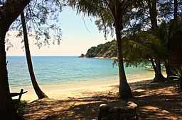
 The beach at Pulau Sibu's Rimba Resort. | |
| Country | Malaysia |
|---|---|
| State | Johor |
| Location | South China Sea |
| - coordinates | 2°12′N 104°05′E / 2.200°N 104.083°E |

Pulau Sibu, also known as Sibu Island, is a small island off Malaysia's eastern coast, facing the South China Sea. It is actually made up of several islands namely Sibu Besar Island, Sibu Tengah Island, Sibu Kukus Island and Sibu Hujung Island.
Sibu Besar, the main island, is approximately 6 km long and 1 km wide, and for the most part covered by tropical vegetation. On the southern end there is a small fishing village called Kampong Duku with a population of fewer than a hundred people (about 40 families).
There are a number of small resorts on the island, typically used as a weekend or short vacation destination from Singapore, since the closest mainland jetty Tanjong Leman is only a roughly 3 hour drive from Singapore via Johor Bahru. The main leisure activities on the island are watersports such as snorkeling and diving - not surprising since the area was designated a Marine Park in 1993 and numerous coral reefs are close to hand.
There are four main beaches on the eastern side of Sibu, where most of the beach resorts are located. Sea Gypsy Village Resort and Dive Base and Sibu Island Cabanas are situated on a beach facing Tinggi Island. Other resorts, such as Rimba Resort, are on the opposite side. Resorts facing the mainland are Coconut Village Resort, Junansa Villa and Twin Beach Resort. Most of the resorts are closed during the annual 3-month monsoon period, save for those facing the mainland.
External links
- Official Sibu Island Travel Information Website
-
 Sibu Island travel guide from Wikivoyage
 - Cabanas Boutique Resort, Spa & PADI Dive Centre - Pulau Sibu
- Sea Gypsy Village Resort & Dive Base on Pulau Sibu
- Rimba Resort
- Junansa Villa
- Sibu Coconut Village Resort
| ||||||||||||||