Pula, Sardinia
| Pula | |
|---|---|
| Comune | |
| Comune di Pula | |
 | |
.svg.png) | |
 Pula | |
| Coordinates: 39°1′N 9°0′E / 39.017°N 9.000°ECoordinates: 39°1′N 9°0′E / 39.017°N 9.000°E | |
| Country | Italy |
| Region | Sardinia |
| Province | Province of Cagliari (CA) |
| Frazioni | S.Margherita di Pula |
| Area | |
| • Total | 138.7 km2 (53.6 sq mi) |
| Elevation | 10 m (30 ft) |
| Population (Dec. 2004) | |
| • Total | 6,937 |
| • Density | 50/km2 (130/sq mi) |
| Demonym | Pulesi |
| Time zone | CET (UTC+1) |
| • Summer (DST) | CEST (UTC+2) |
| Postal code | 09010 |
| Dialing code | 070 |
| Website | Official website |
Pula (Latin: Nora[1]) is a comune (municipality) in the Province of Cagliari in the Italian region Sardinia, located about 25 km southwest of Cagliari. As of 31 December 2004, it had a population of 6,937 and an area of 138.7 km².[2]
The municipality of Pula contains the frazione (subdivision) S.Margherita di Pula.
Pula borders the municipalities of: Domus de Maria, Sarroch, Teulada, Villa San Pietro. Pula is a popular holiday resort with many famous hotels and beaches. The most popular month is August. Pula is also a centre of education with the Alberghiera School and the Wiseword English School, a Trinity Centre for international qualifications.
The Nora archaeological site is a pre-Roman village on which the Romans later built. The theatre and the thermal baths are still in good condition.
History
Pula is located near the ancient city of Nora according to legend founded by the Iberians conducted in Sardinia Norac. Nora was built by Phoenicians around the eighth century BC probably of pre-existing settlements nuragici of which there are some testimonials. He spent the following centuries before the Punic and then to Roman who raised it for a short time in the capital of the province of Sardinia and Corsica , and then give the charge to the nearby Caralis (modern Cagliari). After the end of the Roman Empire , like many other ancient Sardinian coastal cities, because of the Saracen raids, the city of Nora ceased to exist from about the eighth century AD. In the Middle Ages, the area, then called Padulis de Nura (Marsh Nora), was part of the Judges of Cagliari while during the Aragonese period - Spanish was entrusted to various feudal lords. From the eighteenth century, there was a revival mainly due to agricultural reclamation initially promoted by religious and then also state that intensified the reclamation and development of olive and fruit growing.
Monuments and places of interest
Residential area
The country still has a decent center. In Corso Vittorio Emanuele is the Museum Patrons John, archaeological museum which houses relics from Nora. In the church of San Giovanni Battista (nineteenth century), in Piazza Giovanni XXIII, are of marble sarcophagi, one of which contains the remains of a duchess Cagliari. Not far away is the Piazza del Popolo. On the way to Nora meets the aristocratic Villa Santa Maria, designed by Gaetano Cima in the first half of the nineteenth century on the ruins of the ancient church of the same name.
Nora
In the promontory of Capo di Pula there are the ruins of the ancient city founded by Phoenicians, which in all probability is the first and most important center on the island. The remains were discovered accidentally when a violent storm resumed light in one part of the funeral of Tophet. The outstanding discoveries followed one another, the most striking finding was certainly the theater, probably also for its good storage conditions. This work is currently being used for an interesting cultural event.
Not far away a single column indicates the Roman temple and adjacent to it the forum - the social and economic center of the city. Not far away is the temple dedicated to the goddess Tanit, a supposition advanced by the discovery of a stone pyramid, which would appear divinity. A very interesting building is undoubtedly the spa complex, whose ruins just give an idea of the impressiveness of the structure.
Other points of interest
Sardinia Follow the signs to the city of Nora, just before the site stands the church of Sant'Efisio (twelfth century). It was built in the place where the saint was martyred. At the foot of the sanctuary lies the beach Guventeddu (from the Sardinian Guventeddu, small convent). A little further on is the lagoon of Nora, near which was recently founded the Center for Environmental Education, with the aquarium and a series of tanks with marine species most representative of the lagoon ecosystem . After the lagoon, still following the coast road, meet the beaches of Punta d' Agumu and Foxi 'e Sali, in correspondence of the only significant inputs.
Nearby is the large tourist village / Agricultural Santa Margherita di Pula, initially grew around the church dedicated to the Holy Martyr. The large pine forest has been planted in the postwar period, in conjunction with projects of agrarian transformation, and is currently controlled by the tourism sector. In the opposite coast there are the beaches of Cala d'Ostia, where stands the marina and a little further on, the beautiful Cala Verde. Most of the inputs to these beaches are located near tourist centers.
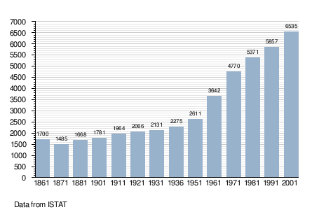
Demographic evolution

See also
- Piscinamanna valley
References
- ↑ Richard Talbert, Barrington Atlas of the Greek and Roman World, (ISBN 0-691-03169-X), Map 48.
- ↑ All demographics and other statistics: Italian statistical institute Istat.
External links
| Wikimedia Commons has media related to Pula (Italy). |