Puebla de Sanabria
From Wikipedia, the free encyclopedia
| Puebla de Sanabria | |||
|---|---|---|---|
 | |||
| |||
 Puebla de Sanabria | |||
| Coordinates: 42°3′19″N 6°38′01″W / 42.05528°N 6.63361°W | |||
| Country | Spain | ||
| Autonomous community | Castile and León | ||
| Province | Zamora | ||
| Comarca | Senabria | ||
| Government | |||
| • Mayor | José Fernández Blanco | ||
| Area | |||
| • Total | 81.39 km2 (31.42 sq mi) | ||
| Elevation | 960 m (3,150 ft) | ||
| Population (2009) | |||
| • Total | 1,571 | ||
| • Density | 19/km2 (50/sq mi) | ||
| Demonym | Sanabrés | ||
| Time zone | CET (UTC+1) | ||
| • Summer (DST) | CEST (UTC+2) | ||
| Website | Official website | ||

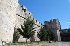
Castle of Puebla de Sanabria
Puebla de Sanabria is a small town located in the north-eastern part of the province of Zamora in Spain, between the rivers Tera and Castro.
It is the economic and political centre of the comarca of Sanabria.
History
Well known as one of the oldest settlements in the province of Zamora, its roots could get to be documented around year 509 where it appears in a record from the Council of Lugo. Some authors have the opinion that the information here found refers to the whole region instead referring only to the town. More accurate documentation can be found around the 10th century in which existed as "urbe Senabrie" indicated as organization center for its surrounding area.
Main sights
- the castle built around the 15th century by the Count of Benavente
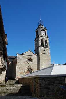
- Romanesque-Gothic church of Nuestra Señora de Azogue (13th century)
- Hermitage of San Cayetano, in Baroque style (17th century)
- Isabeline Town Hall (16th century).
- Fort of San Carlos

Church of Nuestra Señora del Azogue.

Castle of Puebla de Sanabria, Main entrance.
See also
- Lago de Sanabria
External links
| Wikimedia Commons has media related to Puebla de Sanabria. |
- For more information
- Puebla de Sanabria Town Hall
- Puebla de Sanabria in Google Maps
- Fiestas de las Victorias, de Puebla de Sanabria
- Portal de Turismo de Sanabria
This article is issued from Wikipedia. The text is available under the Creative Commons Attribution/Share Alike; additional terms may apply for the media files.

