Puchenau
From Wikipedia, the free encyclopedia
| Puchenau | ||
|---|---|---|
 | ||
| ||
 Puchenau | ||
| Coordinates: 48°18′39″N 14°14′29″E / 48.31083°N 14.24139°ECoordinates: 48°18′39″N 14°14′29″E / 48.31083°N 14.24139°E | ||
| Country | Austria | |
| State | Upper Austria | |
| District | Urfahr-Umgebung | |
| Government | ||
| • Mayor | Wolfgang Haderer (ÖVP) | |
| Area | ||
| • Total | 8.18 km2 (3.16 sq mi) | |
| Elevation | 265 m (869 ft) | |
| Population (1 January 2013)[1] | ||
| • Total | 4,471 | |
| • Density | 550/km2 (1,400/sq mi) | |
| Time zone | CET (UTC+1) | |
| • Summer (DST) | CEST (UTC+2) | |
| Postal codes | 4048, 4040 | |
| Area codes | 0 732, 0 72 34 | |
| Vehicle registration | UU | |
| Website | www.puchenau.at | |

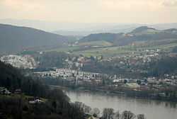
Puchenau is a municipality in the district of Urfahr-Umgebung in Upper Austria, Austria. Until 1893 it was part of the neighbour town Ottensheim.
References
This article is issued from Wikipedia. The text is available under the Creative Commons Attribution/Share Alike; additional terms may apply for the media files.