Province of Perugia
From Wikipedia, the free encyclopedia
| Province of Perugia | ||
|---|---|---|
| Province | ||
| ||
 | ||
| Country |
| |
| Region | Umbria | |
| Capital(s) | Perugia | |
| Comuni | 59 | |
| Government | ||
| • President | Marco Vinicio Guasticchi (PD) | |
| Area | ||
| • Total | 6,334 km2 (2,446 sq mi) | |
| Population (2012) | ||
| • Total | 674,852 | |
| • Density | 110/km2 (280/sq mi) | |
| Time zone | CET (UTC+1) | |
| • Summer (DST) | CEST (UTC+2) | |
| Postal code | 06010-06089, 06100 | |
| Telephone prefix | 075, 0578, 0742, 0743 | |
| Vehicle registration | PG | |
| ISTAT | 054 | |
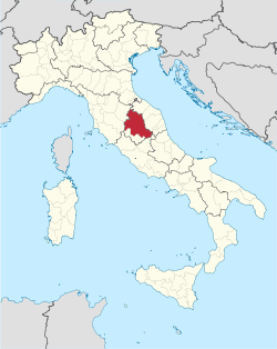
The Province of Perugia (Italian: Provincia di Perugia) is the larger of the two provinces in the Umbria region of Italy, comprising two-thirds of both the area and population of the region. Its capital is the city of Perugia. The province covered all of Umbria until 1927, when the province of Terni was carved out of its southern third. The province of Perugia has an area of 6,334 km², and a total population of about 0.7 million. There are 59 comunes (Italian: comuni) in the province.[1]
Main cities

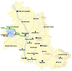
Map of the province of Perugia
The principal towns in the province, with a population over 20,000, are:
| Coat of Arms | City | Population (ab) |
Area (km2) |
|---|---|---|---|
| Perugia | 167,579 | 449 km2 | |
| |
Foligno | 57.917 | 263.7 km2 |
| |
Città di Castello | 40,479 | 387 km2 |
| Spoleto | 39,418 | 349 km2 | |
| Gubbio | 33,018 | 525 km2 | |
| Assisi | 27,942 | 186 km2 | |
| |
Bastia Umbra | 21,800 | 27.6 km2 |
See also
Gallery
-

Perugia, Corso Vannucci.
-

The Orvieto Cathedral.
-
Assisi, Basilica of San Francesco.
References
External links
- Provincia di Perugia homepage (Italian)
| |||||||||||
Coordinates: 43°6′43.56″N 12°23′19.68″E / 43.1121000°N 12.3888000°E
This article is issued from Wikipedia. The text is available under the Creative Commons Attribution/Share Alike; additional terms may apply for the media files.


