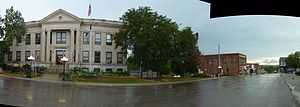
Princeton, Missouri
| Princeton, Missouri | |
|---|---|
| City | |
 | |
 | |
| Coordinates: 40°23′56″N 93°35′9″W / 40.39889°N 93.58583°WCoordinates: 40°23′56″N 93°35′9″W / 40.39889°N 93.58583°W | |
| Country | United States |
| State | Missouri |
| County | Mercer |
| Area[1] | |
| • Total | 1.60 sq mi (4.14 km2) |
| • Land | 1.59 sq mi (4.12 km2) |
| • Water | 0.01 sq mi (0.03 km2) |
| Elevation | 961 ft (293 m) |
| Population (2010)[2] | |
| • Total | 1,166 |
| • Estimate (2012[3]) | 1,148 |
| • Density | 733.3/sq mi (283.1/km2) |
| Time zone | Central (CST) (UTC-6) |
| • Summer (DST) | CDT (UTC-5) |
| ZIP code | 64673 |
| Area code(s) | 660 |
| FIPS code | 29-59942[4] |
| GNIS feature ID | 0724937[5] |
Princeton is the county seat and largest city of Mercer County, Missouri. The population was 1,166 at the 2010 census, up from the 2000 census, which counted 1,047 people.
Geography
Princeton is located at 40°23′56″N 93°35′9″W / 40.39889°N 93.58583°W (40.398794, -93.585807)[6]. According to the United States Census Bureau, the city has a total area of 1.60 square miles (4.14 km2), of which, 1.59 square miles (4.12 km2) is land and 0.01 square miles (0.03 km2) is water.[1]
History
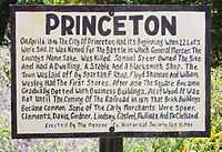
Princeton is the birthplace and childhood home of Calamity Jane. In recognition of this Princeton hosts Calamity Jane Days Fall Festival each September. Martha Jane Cannary (aka Calamity Jane) was born May 1, 1852 in Princeton, Missouri, the oldest of six children. She had two brothers and three sisters.[7] Parents Robert W. and Charlotte Cannary are listed in the 1860 census living nearby in Ravanna, Mercer County, Missouri. The Cannary family moved to Montana in 1865, then on to Salt Lake City, UT where Robert Cannary died.
Early settlers to the area came from Mercer County, West Virginia, which also has a county seat called Princeton.
In 1988 the giant hog finishing company Premium Standard Farms was established in the city.
Demographics
2010 census
As of the census[2] of 2010, there were 1,166 people, 525 households, and 282 families residing in the city. The population density was 733.3 inhabitants per square mile (283.1 /km2). There were 632 housing units at an average density of 397.5 per square mile (153.5 /km2). The racial makeup of the city was 98.9% White, 0.3% African American, 0.2% Native American, 0.2% Asian, 0.3% from other races, and 0.2% from two or more races. Hispanic or Latino of any race were 0.8% of the population.
There were 525 households of which 28.2% had children under the age of 18 living with them, 40.2% were married couples living together, 10.1% had a female householder with no husband present, 3.4% had a male householder with no wife present, and 46.3% were non-families. 41.9% of all households were made up of individuals and 22.4% had someone living alone who was 65 years of age or older. The average household size was 2.12 and the average family size was 2.91.
The median age in the city was 40.3 years. 24.4% of residents were under the age of 18; 6.6% were between the ages of 18 and 24; 23.4% were from 25 to 44; 20.8% were from 45 to 64; and 24.6% were 65 years of age or older. The gender makeup of the city was 47.7% male and 52.3% female.
2000 census
As of the census[4] of 2000, there were 1,047 people, 499 households, and 271 families residing in the city. The population density was 660.5 people per square mile (254.2/km²). There were 566 housing units at an average density of 357.0 per square mile (137.4/km²). The racial makeup of the city was 98.85% White, 0.10% African American, 0.67% Native American, and 0.38% from two or more races. Hispanic or Latino of any race were 0.29% of the population.
There were 499 households out of which 26.1% had children under the age of 18 living with them, 41.1% were married couples living together, 8.8% had a female householder with no husband present, and 45.5% were non-families. 42.9% of all households were made up of individuals and 30.1% had someone living alone who was 65 years of age or older. The average household size was 2.05 and the average family size was 2.79.
In the city the population was spread out with 22.7% under the age of 18, 7.3% from 18 to 24, 21.7% from 25 to 44, 19.9% from 45 to 64, and 28.5% who were 65 years of age or older. The median age was 44 years. For every 100 females there were 77.8 males. For every 100 females age 18 and over, there were 75.1 males.
The median income for a household in the city was $27,059, and the median income for a family was $39,125. Males had a median income of $29,583 versus $19,327 for females. The per capita income for the city was $15,485. About 14.3% of families and 17.3% of the population were below the poverty line, including 22.9% of those under age 18 and 15.8% of those age 65 or over.
Popular culture
Princeton, Missouri is also mentioned in the New York Times bestselling book, "American Gods," written by acclaimed author Neil Gaiman. On page 449, the protagonist finds himself in Princeton at dusk. [8]
Notable residents
- Calamity Jane, also known as Martha Jane Cannary (or Canary) Burke (May 1, 1852 – August 1, 1903) born in Princeton, Missouri.
References
- ↑ 1.0 1.1 "US Gazetteer files 2010". United States Census Bureau. Retrieved 2012-07-08.
- ↑ 2.0 2.1 "American FactFinder". United States Census Bureau. Retrieved 2012-07-08.
- ↑ "Population Estimates". United States Census Bureau. Retrieved 2013-05-30.
- ↑ 4.0 4.1 "American FactFinder". United States Census Bureau. Retrieved 2008-01-31.
- ↑ "US Board on Geographic Names". United States Geological Survey. 2007-10-25. Retrieved 2008-01-31.
- ↑ "US Gazetteer files: 2010, 2000, and 1990". United States Census Bureau. 2011-02-12. Retrieved 2011-04-23.
- ↑ http://www.gutenberg.org/etext/490
- ↑ American Gods, Neil Gaiman, Harpertorch, 2002.
External links
- Historic maps of Princeton in the Sanborn Maps of Missouri Collection at the University of Missouri
| ||||||||||||||||||||
