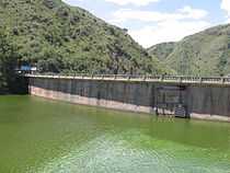
Primero River

The Primero River (in Spanish Río Primero), also known as Suquía (the name used by the Comechingones, the indigenous people), runs through the city of Córdoba, Argentina.
The tributaries of the Primero (mainly the San Roque and Cosquín rivers) flow into the San Roque Reservoir; from there, the Primero goes east into the plains surrounding the city of Córdoba.
Once inside the city, the river channels into La Cañada, a waterway delineated by a stonework canal built through the downtown area, and inaugurated in 1944. Two kilometers to the east, Isla de los Patos (Ducks Island) was repopulated with ducks and swans in the 1980s. During the crisis years of 1988–1991 and 2001–2002, the duck population was devastated, allegedly by people desperately looking for food.[citation needed] It was reported in March 2006 that a large number of ducks had died due to unspecified causes. Pollution by chemical waste is suspected as the cause, but avian influenza is also being investigated as a possible cause.[1]
Beyond the city limits, the river flows towards the Algarrobos swamp and ends its course on the southern coast of the Mar Chiquita (or Mar de Ansenuza) salt lake. All in all, the river has a length of approximately 200 kilometers and carries, on average, 9.7 m³/s, with a minimum of 2 m³/s and a maximum of 24 m³/s, with a peak during the summer months.[2]
Pollution of the water and of the riverbank is a major environmental issue in Córdoba. Periodic cleaning operations are carried out to increase the quality of the water and to preserve the viability of fishing, both in the San Roque reservoir area and downstream.
Note: The major rivers of Córdoba are named by means of Spanish ordinals from north to south: Primero, Segundo, Tercero… (literally: First, Second, Third...); their indigenous names are also used, notably in official documents and geography textbooks. Most people alternate between the two names on a convenience basis.
References
External links
Coordinates: 31°22′30″S 64°28′00″W / 31.37500°S 64.46667°W