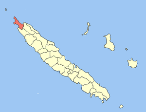
Poum
| Poum | |
|---|---|
 | |
| Coordinates: 20°14′29″S 164°01′01″E / 20.2415°S 164.0169°ECoordinates: 20°14′29″S 164°01′01″E / 20.2415°S 164.0169°E | |
| Country | France |
| Sui generis collectivity | New Caledonia |
| Province | North Province |
| Government | |
| • Mayor | Henriette Tidjine ép. Hmae |
| Area | |
| • Land1 | 469.4 km2 (181.2 sq mi) |
| Population (2004 census) | |
| • Population2 | 1,390 |
| • Population2 Density | 3.0/km2 (7.7/sq mi) |
| Ethnic distribution | |
| • 1996 census |
Kanaks 79.7% Europeans 17.6% Polynesians 0.7% Other 2.0% |
| INSEE/Postal code | 98826 / 98826 |
| Elevation |
0–412 m (0–1,352 ft) (avg. 5 m or 16 ft) |
|
1 New Caledonia Land Register (DITTT) data, which exclude lakes and ponds larger than 1 km² (0.386 sq mi or 247 acres) as well as the estuaries of rivers. 2 Population without double counting: residents of multiple communes (e.g., students and military personnel) only counted once. | |
Poum is a commune in the North Province of New Caledonia, an overseas territory of France in the Pacific Ocean. The town of Poum is located in the far northwest, located on the southern part of Banare Bay, with Mouac Island just offshore.
Poum sits within the world's largest lagoon and is rich in Kanak culture. This region offers a choice of four white beaches and aqua waters.
"It feels a little like the back of beyond - you're truly in the far North of Grande Terre here, with pink-hued mountains and white sandy beaches. The region around Poum offers great landscapes to visitors. A really special light lends nature amazing colours - there is an opportunity for you to take wonderful early morning photos."
History
The commune of Poum was created on 5 January 1977 by detaching its territory from the commune of Koumac.
| Wikimedia Commons has media related to Poum. |
| ||||||||