Poullignac
From Wikipedia, the free encyclopedia
| Poullignac | |
|---|---|
 | |
 Poullignac | |
|
Location within Poitou-Charentes region  Poullignac | |
| Coordinates: 45°24′00″N 0°01′09″W / 45.4°N 0.0192°WCoordinates: 45°24′00″N 0°01′09″W / 45.4°N 0.0192°W | |
| Country | France |
| Region | Poitou-Charentes |
| Department | Charente |
| Arrondissement | Angoulême |
| Canton | Montmoreau-Saint-Cybard |
| Intercommunality | Montmorélien |
| Government | |
| • Mayor (2008–2014) | Mireille Neeser |
| Area | |
| • Land1 | 8.94 km2 (3.45 sq mi) |
| Population (2008) | |
| • Population2 | 80 |
| • Population2 Density | 8.9/km2 (23/sq mi) |
| INSEE/Postal code | 16267 / 16190 |
| Elevation |
63–167 m (207–548 ft) (avg. 80 m or 260 ft) |
|
1 French Land Register data, which excludes lakes, ponds, glaciers > 1 km² (0.386 sq mi or 247 acres) and river estuaries. 2 Population without double counting: residents of multiple communes (e.g., students and military personnel) only counted once. | |
Poullignac is a commune in the Charente department in southwestern France.
Population
| Historical population | ||
|---|---|---|
| Year | Pop. | ±% |
| 1793 | 355 | — |
| 1800 | 345 | −2.8% |
| 1806 | 284 | −17.7% |
| 1821 | 303 | +6.7% |
| 1831 | 327 | +7.9% |
| 1841 | 301 | −8.0% |
| 1846 | 310 | +3.0% |
| 1851 | 323 | +4.2% |
| 1856 | 293 | −9.3% |
| 1861 | 323 | +10.2% |
| 1866 | 300 | −7.1% |
| 1872 | 263 | −12.3% |
| 1876 | 255 | −3.0% |
| 1881 | 256 | +0.4% |
| 1886 | 247 | −3.5% |
| 1891 | 257 | +4.0% |
| 1896 | 211 | −17.9% |
| 1901 | 188 | −10.9% |
| 1906 | 213 | +13.3% |
| 1911 | 216 | +1.4% |
| 1921 | 193 | −10.6% |
| 1926 | 170 | −11.9% |
| 1931 | 188 | +10.6% |
| 1936 | 182 | −3.2% |
| 1946 | 162 | −11.0% |
| 1954 | 159 | −1.9% |
| 1962 | 154 | −3.1% |
| 1968 | 143 | −7.1% |
| 1975 | 102 | −28.7% |
| 1982 | 124 | +21.6% |
| 1990 | 97 | −21.8% |
| 1999 | 77 | −20.6% |
| 2008 | 80 | +3.9% |
Sights
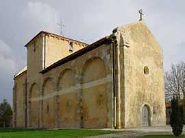
The Romanesque Church of Saint-Martin, built from the end of the 11th century to the beginning of the 12th, was classified as a historic monument in 1987. The apse was replaced in the 12th century with the current barrel vault choir. The brick vault in the nave dates from 1844. There are murals painted in the choir, and traces of paintings in the rest of the church.[1]
See also
References
| Wikimedia Commons has media related to Poullignac. |
This article is issued from Wikipedia. The text is available under the Creative Commons Attribution/Share Alike; additional terms may apply for the media files.