Polesia
| Polesia | |
|---|---|
| Natural and historical region | |
| Cyrillic transcription(s) | |
| • Ukrainian | Полі́сся |
| • Transliteration | Polissia |
| • Belarusian | Пале́ссе |
| • Transliteration | Paleśsie |
| • Russian | Поле́сье |
| • Transliteration | Poles'e |
 | |
 | |
| Countries | Ukraine, Belarus, Russia and Poland |
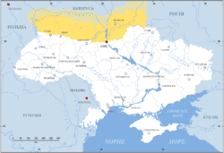
Polesia (Belarusian: Пале́ссе Paleśsie, Polish: Polesie, Russian: Поле́сье Poles'e, Ukrainian: Полі́сся Polissia) is a natural and historical region of the Eastern Europe. One of the largest forest areas in Europe, Polesia located in the south-western part of the Eastern-European Lowland, mainly within Belarus and Ukraine but also partly within Poland and Russia. The swampy areas of Polesia are known as the Pripyat Marshes (after the Pripyat River) or Pinsk Marshes (after the major local city of Pinsk). Large parts of the region were contaminated after the Chernobyl disaster and the region now includes the Chernobyl Exclusion Zone.
Name
The name Polesia is based on the root les, which means "forest" and the prefix po which means on or in.[1] An inhabitant of Polesia is called Poleszuk in Polish; Palyashuk in Belarusian, Polishchuk in Ukrainian, and Poleshchuk in Russian.

Geography
Polesia is a marshy region lining the Pripyat River in Southern Belarus (Brest, Pinsk, Kalinkavichy, Homel), Northern Ukraine (in the Volyn, Rivne, Zhytomyr, Kiev, and Chernihiv Oblasts), and partly in Poland (Lublin) and Russia (Bryansk). It is a flatland within the watersheds of the Southern Bug and Prypyat rivers. The two rivers are connected by the Dnieper-Bug Canal, built during the reign of Stanislaus II of Poland, the last king of the Polish-Lithuanian Commonwealth.
Notable tributaries of the Pripyat are the Horyn, Stokhod, Styr, Ptsich, and Yaselda rivers. The largest towns in the Pripyat basin are Pinsk, Stolin, Davyd-Haradok. Huge marshes were reclaimed from the 1960s to the 1980s for farmland. The reclamation is believed to have harmed the environment along the course of the Pripyat.
This region suffered severely from the Chernobyl disaster. Huge areas were polluted by radioactive elements. Part of the region includes the Chernobyl Exclusion Zone and other areas are considered unsuitable for living.[2]
Polesia has rarely been a separate administrative unit. However, there was a Polesie Voivodeship during the Second Polish Republic, as well as a Polesia Voblast in Byelorussian SSR.
Protected status. Sightseeing
The Polish part of the region includes the Polesie National Park (Poleski Park Narodowy), established 1990, which covers an area of 97.6 square kilometres (37.7 sq mi). This and a wider area adjoining it (up to the Ukrainian border) make up the UNESCO-designated West Polesie Biosphere Reserve, which borders a similar reserve (the Shatskiy Biosphere Reserve) on the Ukrainian side.
There is also a protected area called Pribuzhskoye-Polesie in the Belarusian part of the region.
The wooden architecture structures in the region were added to the UNESCO World Heritage Tentative List on January 30, 2004 in the Cultural category.[3]
The Ukrainian Polesia had its own tradition of folk icon-painting. The images of the saints are peaceful and stable, having deep eyes. The plots were often depicted on the background of landscapes with trees, sky, forests etc. The Ukrainian Polesia's icons' collection is the part of the exhibition of the Museum of Ukrainian home icons in the Historical and cultural complex "The Radomysl Castle".[4]
See also
| Wikimedia Commons has media related to Polesia. |
- UNESCO World Heritage Centre
- Museum of Ukrainian home icons
- Radomysl Castle
References
- ↑ Mould, R. F. (2000). Chernobyl Record: The Definitive History of the Chernobyl Catastrophe. Bristol, UK: Institute of Physics Publishing. ISBN 0-7503-0670-X.
- ↑ "Zoning of radioactively contaminated territory of Ukraine according to actual regulations". ICRIN. 2004. Retrieved 25 April 2012.
- ↑ "Worship wooden architecture (17th -18th centuries) in Polesye - UNESCO World Heritage Centre". Whc.unesco.org. 2004-01-30. Retrieved 2013-01-13.
- ↑ Богомолець. О. "Замок-музей Радомисль на Шляху Королів Via Regia". — Київ, 2013