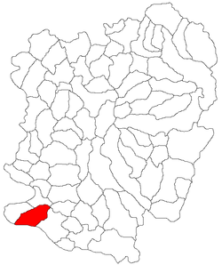
Pojejena
| Pojejena Пожежена / Požežena | |
|---|---|
| Commune | |
 | |
 Pojejena | |
| Coordinates: 44°46′N 21°35′E / 44.767°N 21.583°E | |
| Country |
|
| County | Caraş-Severin County |
| Population (2011)[1] | |
| • Total | 2,585 |
| Time zone | EET (UTC+2) |
| • Summer (DST) | EEST (UTC+3) |
Pojejena (Romanian: Pojejena, pronounced [poʒeʒena]; Serbian: Пожежена or Požežena; Hungarian: Alsópozsgás) is a commune in Caraş-Severin County, Romania. Тhe commune is located in the geographical area known as Clisura Dunării (Banatska Klisura in Serbian). In 2011, its population numbered 2,585 people, of whom the slight majority are ethnic Serbs. It is composed of five villages: Belobreșca (Белобрешка; Fejérdomb), Divici (Дивић; Divécs), Pojejena, Radimna (Радимна; Rádonya) and Șușca (Шушка; Sisak).
Demographics
In 2011, its population was made up of:
Languages
The commune is officially bilingual, with both Romanian and Serbian being used as working languages on public signage and in administration, education and justice.
Climate
Climate in this area has mild dfferences between highs and lows, and there is adequate rainfall year round. The Köppen Climate Classification subtype for this climate is "Cfb" (Marine West Coast Climate/Oceanic climate).[2]
| Climate data for BPojejena | |||||||||||||
|---|---|---|---|---|---|---|---|---|---|---|---|---|---|
| Month | Jan | Feb | Mar | Apr | May | Jun | Jul | Aug | Sep | Oct | Nov | Dec | Year |
| Average high °C (°F) | 2 (35) |
4 (39) |
11 (51) |
17 (62) |
22 (71) |
24 (75) |
28 (82) |
28 (82) |
24 (75) |
17 (62) |
9 (48) |
3 (37) |
15.8 (59.9) |
| Average low °C (°F) | −2 (28) |
−1 (30) |
1 (33) |
6 (42) |
10 (50) |
13 (55) |
14 (57) |
14 (57) |
11 (51) |
7 (44) |
2 (35) |
−1 (30) |
6.2 (42.7) |
| Precipitation mm (inches) | 66 (2.6) |
64 (2.5) |
61 (2.4) |
89 (3.5) |
140 (5.5) |
180 (7.1) |
145 (5.7) |
124 (4.9) |
91 (3.6) |
66 (2.6) |
69 (2.7) |
80 (3) |
1,175 (46.1) |
| Source: Weatherbase [3] | |||||||||||||
See also
- Caraş-Severin County
- Clisura Dunării
- Serbs in Romania
References
- ↑ (Romanian) "Pojejena", at the Erdélyi Magyar Adatbank's Recensământ 2002; Retrieved on August 23, 2009
- ↑ Climate Summary for Pojejena
- ↑ "Weatherbase.com". Weatherbase. 2013. Retrieved on July 14, 2013.
Coordinates: 44°46′N 21°35′E / 44.767°N 21.583°E
