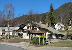
Podreber, Dobrova–Polhov Gradec
From Wikipedia, the free encyclopedia
| Podreber | |
|---|---|
 | |
_location_map.svg.png) Podreber | |
| Coordinates: 46°3′49.55″N 14°19′16.11″E / 46.0637639°N 14.3211417°ECoordinates: 46°3′49.55″N 14°19′16.11″E / 46.0637639°N 14.3211417°E | |
| Country |
|
| Traditional region | Upper Carniola |
| Statistical region | Central Slovenia |
| Municipality | Dobrova–Polhov Gradec |
| Area | |
| • Total | 1.14 km2 (0.44 sq mi) |
| Elevation | 400.2 m (1,313.0 ft) |
| Population (2002) | |
| • Total | 113 |
| [1] | |
Podreber (pronounced [pɔˈdreːbər]) is a small settlement east of the town of Polhov Gradec in the Municipality of Dobrova–Polhov Gradec in the Upper Carniola region of Slovenia.[2] It lies on the road from Ljubljana to Polhov Gradec below Kucelj Hill (705 m).[3]
Name
The name Podreber is derived from a prepositional phrase in which the noun has lost its case ending: pod 'below' + reber 'slope'. The name therefore means 'below the slope' and refers to the settlement's position on the south slope of Kucelj Hill.
Church

St. Elizabeth's Church
References
- ↑ Statistical Office of the Republic of Slovenia
- ↑ Dobrova–Polhov Gradec municipal site
- ↑ 3.0 3.1 Savnik, Roman, ed. 1971. Krajevni leksikon Slovenije, vol. 2. Ljubljana: Državna založba Slovenije. p. 425.
External links
| |||||||||||||
This article is issued from Wikipedia. The text is available under the Creative Commons Attribution/Share Alike; additional terms may apply for the media files.
