Plessur Alps
| Plessur Alps | |
|---|---|
 Aroser Weisshorn (2,653m/8,704ft) | |
| Highest point | |
| Peak | Aroser Rothorn |
| Elevation | 2,985 m (9,793 ft) |
| Coordinates | 46°44′N 9°38′E / 46.733°N 9.633°ECoordinates: 46°44′N 9°38′E / 46.733°N 9.633°E |
| Geography | |
| Country | Switzerland |
| State | Graubünden |
| Parent range | Central Eastern Alps |
The Plessur Alps are a mountain range in the Alps of eastern Switzerland. They are considered to be part of the Central Eastern Alps. They are named after the river Plessur, which originates from the center of the ranges. The Plessur Alps are separated from the Glarus Alps in the west by the Rhine valley; from the Rätikon range in the north by the Landquart river valley (Prättigau); from the Albula Alps in the south-east by the Landwasser river valley; from the Oberhalbstein Alps in the south by the Albula river valley.
The Plessur Alps are drained by the rivers Rhine, Plessur, Landwasser and Landquart. The ski resort Arosa lies in the middle of the range.
Peaks of the Plessur Alps are the Aroser Rothorn (highest, 2985m = 9794 ft) and Stätzer Horn (2576m = 8450 ft).
A mountain pass in the Plessur Alps is the Strela Pass, from Davos to Langwies, elevation 2377m.
Gallery
-
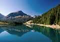
Lake near Arosa
-

Valley of Lenzerheide
-
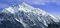
Lenzer Horn
-

Parpaner Rothorn (right)
-
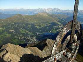
Summit of Lenzer Horn
.jpg)
See also
References
- Swisstopo maps
| Wikimedia Commons has media related to Plessur Range. |
External links
| |||||||
