Plácido de Castro
From Wikipedia, the free encyclopedia
For the football team, see Plácido de Castro Futebol Club.
For the airport, see Rio Branco International Airport.
Coordinates: 10°16′33″S 67°09′00″W / 10.27583°S 67.15000°W
| Plácido de Castro | |||
|---|---|---|---|
| |||
 | |||
 Plácido de Castro | |||
| Coordinates: 10°16′33″S 67°09′00″W / 10.27583°S 67.15000°W | |||
| Country |
| ||
| State | Acre | ||
| Area | |||
| • Total | 790 sq mi (2,047 km2) | ||
| Population (2007) | |||
| • Total | 17 258 | ||
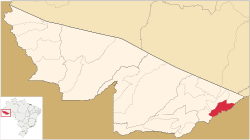
Plácido de Castro is a municipality located in the east of the Brazilian state of Acre. It has a population of 17,258 and its area is 2,047 km².
The surrounding area has several large, ancient earthworks termed "geoglifos" by regional archaeologists. An example is clearly visible in aerial photography at -10.307S, -67.218W.
| |||||||||||||||||||||||
This article is issued from Wikipedia. The text is available under the Creative Commons Attribution/Share Alike; additional terms may apply for the media files.


