Pingtung County
| Pingtung County 屏東縣 Abbreviation(s): Pingtung (屏東) | |||
|---|---|---|---|
| County | |||
 | |||
| |||
 | |||
| Coordinates: 22°40′31.78″N 120°29′29.09″E / 22.6754944°N 120.4914139°ECoordinates: 22°40′31.78″N 120°29′29.09″E / 22.6754944°N 120.4914139°E | |||
| Country | Taiwan | ||
| Region | Southern Taiwan | ||
| Seat | Pingtung City | ||
| Largest city | Pingtung City | ||
| Boroughs | 1 cities, 32 (3 urban, 29 rural) townships | ||
| Government | |||
| • County Magistrate | Tsao Chi-hung | ||
| Area | |||
| • Total | 2,775.6003 km2 (1,071.6653 sq mi) | ||
| Area rank | 5 of 22 | ||
| Population (June 2007) | |||
| • Total | 890,753 | ||
| • Rank | 10 of 22 | ||
| • Density | 320/km2 (830/sq mi) | ||
| Website | www.pthg.gov.tw (English) | ||
| Symbols | |||
| Flower | Hairy Bougainvillea (Bougainvillea brasiliensis) | ||
| Tree | Coconut tree | ||


| Pingtung County | |||||||||||||
| Simplified Chinese | 屏东县 | ||||||||||||
|---|---|---|---|---|---|---|---|---|---|---|---|---|---|
| Traditional Chinese | 屏東縣 | ||||||||||||
| |||||||||||||


Pingtung County (Chinese: 屏東縣; pinyin: Píngdōng Xiàn) is a county in Southern Taiwan. It consists of the oldest and the largest national park in Taiwan, Kenting National Park, established in Pingtung County in 1984. Pingtung City is the capital of Pingtung County.
History
Modern-day Pingtung County and Kaohsiung City were part of Wan-nien Province (萬年州) during the Kingdom of Tungning and Fengshan Prefecture in the Qing Dynasty. Pingtung County is a recently developed county. Its largest city is Pingtung City. The name Pingtung refers to a former nearby mountain known as Half-Screen Mountain (半屏山). Pingtung means "East of Half-Screen Mountain."
Until the seventeenth century this area of Taiwan was a place of exile for Chinese criminals and occasional landing point for international mariners. Only the settlements near present-day Checheng Township existed. In 1664 Chinese, Cantonese and Hakka settlers arrived from China and farmed under a homesteading system introduced by Zheng Jing.
Pingtung City, the biggest city in Pingtung County, also known as "A-Kau" (阿猴 Pe̍h-ōe-jī: A-kâu), was the home of Pingpu Aboriginals. In their language, "A-kau" means "the forest".
The first settlements by Han people were not established until 1684 (the 23rd year of Kangxi) with the creation of villages near Pingtung by people from China's southern Fujian region. By 1734 most of the Pingtung plain was cultivated and in 1764 Pingtung was expanded. In 1836 the government and locals worked together to build the four walls of the city (the North gate, the East gate, the West gate and the South gate), and the roads were also properly finished. (Translated from the website of Cultural Affairs Bureau of Pingtung County)
Under Japanese rule (1895–1945) the Pingtung area became a favourite spot for relaxation.
Pingtung was the site of an 7.1 magnitude earthquake on 26 December 2006. In 2009, Pingtung received rainfall in excess of 2,500 millimetres (98 in); breaking all rainfall records of any single place in Taiwan induced by a single typhoon.
Geography
With a land area of over 2775km², Pingtung is the 5th largest county in Taiwan, the 2nd largest of Southern Taiwan after Kaohsiung City. Geographically it borders Kaohsiung City to the north, Taitung County to the east, the Taiwan Strait to the west and the Bashi Channel to the south. Due to being located at the southern most part of Taiwan, Pingtung County has one of the warmest climate on average within the country. The whole county experiences a tropical wet and dry climate, with the exception of the Hengchun Peninsula where it has a tropical savanna climate. Due to being such a large county, climate differs in different areas of the county. Northern Pingtung, such as the Pingtung City, is characterized by having a high daily maximum temperature year round, averaging from 29-33 during the warmer season of april-november to 24-28 during the cooler season of december-march while having the lowest night time temperatures within the county during winter with temperatures usually dropping below 15 degrees at night in January due to being located more further away from the sea than any other flatlands within the county. Central Pingtung, such as the Fangliao Township, compared to northern Pingtung, has a relatively lower daily maximum temperature during mid-day but has warmer nights due to the temperating affect of the ocean especially noticeable during winter. The southern tip of Pingtung, the Hengchun Peninsula has the mildest climate within the county due to being nearly completely surrounded by the Pacific Ocean with the exception of the mountains on the north. Daily highs during the warmer season reaches around 28-31 while daily highs during the cooler season varies around 22-25 degrees C but on the other hand night time temperatures maintains pretty warm throughout the year from around 25 degrees during summer to around 20 degrees during the winter.
| Climate data for Pingtung City (Northern Pingtung) (1981–2012) | |||||||||||||
|---|---|---|---|---|---|---|---|---|---|---|---|---|---|
| Month | Jan | Feb | Mar | Apr | May | Jun | Jul | Aug | Sep | Oct | Nov | Dec | Year |
| Average high °C (°F) | 25.5 (77.9) |
26.2 (79.2) |
28.6 (83.5) |
30.9 (87.6) |
32.2 (90) |
33.0 (91.4) |
33.7 (92.7) |
33.4 (92.1) |
32.9 (91.2) |
31.5 (88.7) |
29.5 (85.1) |
26.9 (80.4) |
30.36 (86.65) |
| Daily mean °C (°F) | 20.0 (68) |
20.9 (69.6) |
23.5 (74.3) |
26.0 (78.8) |
27.9 (82.2) |
28.8 (83.8) |
29.5 (85.1) |
29.2 (84.6) |
28.4 (83.1) |
27.1 (80.8) |
24.5 (76.1) |
20.9 (69.6) |
25.56 (78) |
| Average low °C (°F) | 14.8 (58.6) |
15.7 (60.3) |
18.5 (65.3) |
21.8 (71.2) |
24.3 (75.7) |
25.6 (78.1) |
26.3 (79.3) |
26.0 (78.8) |
25.1 (77.2) |
23.6 (74.5) |
20.5 (68.9) |
16.0 (60.8) |
21.52 (70.72) |
| [citation needed] | |||||||||||||
| Climate data for Fangliao Township (Central Pingtung) (1981–2012) | |||||||||||||
|---|---|---|---|---|---|---|---|---|---|---|---|---|---|
| Month | Jan | Feb | Mar | Apr | May | Jun | Jul | Aug | Sep | Oct | Nov | Dec | Year |
| Average high °C (°F) | 25.5 (77.9) |
26.1 (79) |
28.1 (82.6) |
30.5 (86.9) |
31.8 (89.2) |
32.6 (90.7) |
33.3 (91.9) |
33.0 (91.4) |
32.5 (90.5) |
31.1 (88) |
29.0 (84.2) |
26.5 (79.7) |
30 (86) |
| Average low °C (°F) | 16.1 (61) |
17.1 (62.8) |
19.5 (67.1) |
22.6 (72.7) |
24.9 (76.8) |
26.0 (78.8) |
26.5 (79.7) |
26.2 (79.2) |
25.6 (78.1) |
24.2 (75.6) |
21.3 (70.3) |
17.5 (63.5) |
22.29 (72.13) |
| [citation needed] | |||||||||||||
| Climate data for Hengchun Township (Southern Pingtung) (1983–2012) | |||||||||||||
|---|---|---|---|---|---|---|---|---|---|---|---|---|---|
| Month | Jan | Feb | Mar | Apr | May | Jun | Jul | Aug | Sep | Oct | Nov | Dec | Year |
| Average high °C (°F) | 24.8 (76.6) |
25.3 (77.5) |
27.4 (81.3) |
29.4 (84.9) |
31.0 (87.8) |
31.3 (88.3) |
31.9 (89.4) |
31.6 (88.9) |
31.0 (87.8) |
29.6 (85.3) |
27.6 (81.7) |
25.2 (77.4) |
28.84 (83.91) |
| Average low °C (°F) | 18.1 (64.6) |
18.7 (65.7) |
20.2 (68.4) |
22.3 (72.1) |
24.1 (75.4) |
25.2 (77.4) |
25.6 (78.1) |
25.3 (77.5) |
24.7 (76.5) |
23.9 (75) |
22.0 (71.6) |
19.3 (66.7) |
22.5 (72.5) |
| Rainfall mm (inches) | 25.7 (1.012) |
27.7 (1.091) |
19.9 (0.783) |
43.5 (1.713) |
163.9 (6.453) |
371.3 (14.618) |
396.3 (15.602) |
475.2 (18.709) |
288.3 (11.35) |
141.8 (5.583) |
43.2 (1.701) |
20.6 (0.811) |
2,017.4 (79.425) |
| Avg. rainy days (≥ 0.1 mm) | 8.0 | 6.8 | 4.8 | 6.3 | 11.1 | 16.9 | 16.4 | 18.9 | 15.9 | 10.8 | 7.1 | 6.1 | 129.1 |
| % humidity | 72.6 | 73.7 | 74.4 | 75.4 | 78.5 | 83.6 | 83.3 | 84.0 | 79.7 | 74.0 | 70.8 | 70.7 | 76.7 |
| Mean monthly sunshine hours | 171.7 | 168.4 | 206.9 | 205.3 | 201.8 | 192.8 | 227.5 | 197.1 | 192.1 | 200.0 | 178.0 | 162.0 | 2,303.6 |
| Source: [1] | |||||||||||||
Administration
Pingtung County is divided into 1 city, 3 urban townships and 29 rural townships. Pingtung County has the most number of rural townships among other counties in Taiwan.
| Name (mostly Hanyu Pinyin) | Hanzi | Wade-Giles | Tongyong Pinyin | Taiwanese (POJ) | Hakka Pha̍k-fa-sṳ |
|---|---|---|---|---|---|
| City | |||||
| Pingtung City | 屏東市 | P'ing-tung | Pingdong | Pîn-tong | Phìn-tûng |
| Urban townships | |||||
| Chaozhou Township | 潮州鎮 | Ch'ao-chou | Chaojhou | Tiô-chiu | Tshèu-chû |
| Donggang Township | 東港鎮 | Tung-kang | Donggang | Tang-káng | Tûng-kóng |
| Hengchun Township | 恆春鎮 | Heng-ch'un | Hengchun | Hêng-chhun | Hèn-tshûn |
| Rural townships | |||||
| Changzhi Township | 長治鄉 | Ch'ang-Chih | Changjhih | Tióng-tī | Tshòng-tshṳ |
| Checheng Township | 車城鄉 | Ch'e-ch'eng | Checheng | Chhia-siâⁿ | Tshâ-sàng |
| Chunri Township | 春日鄉 | Ch'un-jih | Chunrih | Chhun-ji̍t | Tshûn-ngit |
| Fangliao Township | 枋寮鄉 | Fang-liao | Fangliao | Pang-liâu | Piông-liàu |
| Fangshan Township | 枋山鄉 | Fang-shan | Fangshan | Pang-soaⁿ | Piông-sân |
| Gaoshu Township | 高樹鄉 | Kao-shu | Gaoshu | Ko-chhiū | Kô-su |
| Jiadong Township | 佳冬鄉 | Chia-tung | Jiadong | Ka-tang | Kâ-tûng |
| Jiuru Township | 九如鄉 | Chiu-ju | Jiouru | Kíu-jû | Kiú-yì |
| Kanding Township | 崁頂鄉 | K'an-ting | Kanding | Khàm-téng | Kham-táng |
| Laiyi Township | 來義鄉 | Lai-i | Laiyi | Lâi-gī | Lòi-ngi |
| Ligang Township | 里港鄉 | Li-kang | Ligang | Lí-káng | Lî-kóng |
| Linbian Township | 林邊鄉 | Lin-pian | Linbian | Nâ-piⁿ | Lìm-piên |
| Linluo Township | 麟洛鄉 | Lin-luo | Linluo | Lîn-lo̍k | Lìm-lo̍k |
| Liuqiu Township | 琉球鄉 | Liu-ch'iu | Liouciou | Liû-khiû | Liù-khiù |
| Majia Township | 瑪家鄉 | Ma-chia | Majia | Má-ka | Mâ-kâ |
| Manzhou Township | 滿州鄉 | Man-chou | Manjhou | Bóan-chiu | Mân-chû |
| Mudan Township | 牡丹鄉 | Mu-tan | Mudan | Bó͘-tan | Méu-tân |
| Nanzhou Township | 南州鄉 | Nan-chou | Nanjhou | Lâm-chiu | Nàm-chû |
| Neipu Township | 內埔鄉 | Nei-p'u | Neipu | Lāi-po͘ | Lui-phû |
| Sandimen Township | 三地門鄉 | San-ti-men | Sandimen | Soaⁿ-tē-mn̂g | Sâm-thi-mùn |
| Shizi Township | 獅子鄉 | Shih-tzu | Shihzih | Sai-chú | Sṳ̂-é |
| Taiwu Township | 泰武鄉 | T'ai-wu | Taiwu | Thài-bú | Thai-vú |
| Wandan Township | 萬丹鄉 | Wan-tan | Wandan | Bān-tan | Van-tân |
| Wanluan Township | 萬巒鄉 | Wan-luan | Wanluan | Bān-loân | Van-lòng |
| Wutai Township | 霧臺鄉 | Wu-t'ai | Wutai | Bū-tâi | Vu-thòi |
| Xinpi Township | 新埤鄉 | Hsin-p'i | Sinpi | Sin-pi | Sîn-phî |
| Xinyuan Township | 新園鄉 | Hsin-yuan | Sinyuan | Sin-hn̂g | Sîn-yèn |
| Yanpu Township | 鹽埔鄉 | Yen-p'u | Yanpu | Iâm-po͘ | Yâm-phû |
| Zhutian Township | 竹田鄉 | Chu-t'ien | Jhutian | Tek-chhân | Tsuk-thièn |
Higher education
- National Pingtung University of Education
- National Pingtung University of Science and Technology
- National Pingtung Institute of Commerce
- Tajen University
- Yung Ta Institute of Technology and Commerce
- Meiho Institute of Technology
- Kao Fong College
Tourist attractions
- Fangliao F3 Art Venue
Located just a few minutes'walk from Fangliao train station, the art village stretches around 3,000 square meters which provides artists in residence plenty of room to work and live. Converted from old dormitories that once belonged to the Taiwan Railway Administration, the art village has been part of the Art Network of Railway Warehouses run by the Council for Cultural Affairs since 2002.[2]
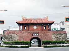
- Ahou City Gate
- Black Pearl – Top Quality Wax Apple
- Checheng Fuan Temple
- Danlin Suspension Bridge
- Eluanbi Lighthouse
- Hengchun Chuhuo Natural Fire
- Indigenous Culture Hall
- Jialeshuei
- Kaoping Iron Railway Bridge
- Kaoping Riverfront Park
- Kapok Trees
- Kenting National Park
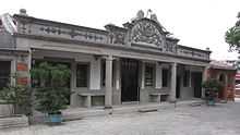
- Kuan Hai Shan Academy
- Landscpe of Manjhou
- Linben Riverfront Park
- Loacijia Slate Houses
- Longkeng Conservation Area
- Longluan Lake
- Longpan Park
- Mobitou
- Mudan Reservoir
- National Museum of Marine Biology and Aquarium
- Sinpi Jian-gong Water Park
- Tungkang Tunglung Temple
- Wanjin Basilica
See also
- County (Taiwan)
- List of magistrates of Pingtung County
- Hengchun Township
- Southern Taiwan
- Pingtung City
Notes
- ↑ "Statistics > Monthly Mean". Central Weather Bureau.
- ↑ "Art at the Crossroads: F3's Undetermined Future in Fangliao", by Eva Tang, 12 February 2009, Taiwan Culture Portal http://www.culture.tw/index.php?option=com_content&task=view&id=1114&Itemid=157
External links
| Wikimedia Commons has media related to Pingtung. |
- Pingtung County Government (English)
| ||||||||||||||||||||

| |||||||||||||||||||||