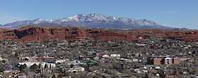
Pine Valley Mountains
| Pine Valley Mountains | |
|---|---|
 Pine Valley Mountains and St. George | |
| Highest point | |
| Peak | Signal Peak |
| Elevation | 10,365 ft (3,159 m) |
| Coordinates | 37°19′11″N 113°29′30″W / 37.3197027°N 113.4916207°WCoordinates: 37°19′11″N 113°29′30″W / 37.3197027°N 113.4916207°W |
| Dimensions | |
| Length | 35 mi (56 km) N/S |
| Width | 28 mi (45 km) E/W |
| Area | 591 sq mi (1,530 km2) |
| Geography | |
<div style="padding:2px 2px 2px 2px;> | |
| Country | United States |
| State | Utah |
The Pine Valley Mountains are a mountain range in the U.S. state of Utah spanning Washington County north of the city of St. George.[1] The highest point in the range is Signal Peak at 10,365 feet (3,159 m).[2][3][4] The mountains are part of Dixie National Forest and are bordered to the south by the Red Cliffs National Conservation Area.
Geology
The Pine Valley Mountains formed from the Pine Valle Laccolith, which is the largest laccolith in the United States and perhaps the largest laccolith in the world.[5] The mountains are in the watershed of the Virgin River, a tributary of the Colorado River. Zion National Park can be seen to the east from the mountains.
Wilderness
Part of the range is in the Pine Valley Mountain Wilderness, which at 50,232 acres (20,328 ha) is the fourth largest wilderness in Utah.[6] The 2,643 acres (1,070 ha) Cottonwood Forest Wilderness is located at the southeastern end of the range.[7]
Flora and fauna
The Pine Valley Mountains support spruce-fir forests, including a large stand of virgin Englemann spruce. The mountains also have numerous meadows up to 50 acres (20 ha) in size.[6] Several threatened, endangered, and sensitive species live in the mountains, including Bonneville Cutthroat Trout, Townsend's big-eared bat, and the Pygmy Rabbit, among others.
Recreation
There are numerous opportunities for recreation in the mountains, including hiking, rock climbing, camping, wildlife watching, fishing, hunting, horseback riding, and boating on a reservoir.[8][9]
Peaks
| Mountain Peak | Elevation | Prominence | Isolation | Location |
|---|---|---|---|---|
| Signal Peak | !B9919419891991 10,364 ft 3159 m | !B9927796261632 4,485 ft 1367 m | !B9888977532101 41 mi 66 km |
37°19′10″N 113°29′32″W / 37.319537°N 113.492205°W |
| Burger Peak | !B9919461129163 10,322 ft 3146 m | !B9955456527037 282 ft 86 m | !B9930626859187 0.6 mi 1.0 km |
37°19′32″N 113°30′04″W / 37.325469°N 113.501154°W |
| Big Point | !B9919754651283 10,023 ft 3055 m | !B9942764148980 1,004 ft 306 m | !B9907542924841 6 mi 10 km |
37°24′51″N 113°22′51″W / 37.4141°N 113.3809°W |
| Gardner Peak | !B9920302964167 9,488 ft 2892 m | !B9958568652736 207 ft 63 m | !B9909498283801 5.3 mi 8.5 km |
37°23′29″N 113°27′06″W / 37.391335°N 113.451708°W |
| Timber Mountain | !B9920806438093 9,022 ft 2750 m | !B9949310957977 522 ft 159 m | !B9912741679434 3.8 mi 6.2 km |
37°28′15″N 113°23′46″W / 37.4708°N 113.3961°W |
| Mount Baldy | !B9920949271505 8,894 ft 2711 m | !B9953178687728 354 ft 108 m | !B9920240916398 1.8 mi 2.9 km |
37°25′53″N 113°20′11″W / 37.4314°N 113.3364°W |
| Rencher Peak | !B9921068011304 8,789 ft 2679 m | !B9945446788846 768 ft 234 m | !B9917160006957 2.5 mi 4.0 km |
37°30′06″N 113°24′41″W / 37.5016°N 113.4114°W |
| Snow Benchmark | !B9925627936331 5,571 ft 1698 m | !N unknown | !B9901968854216 11 mi 18 km |
37°15′06″N 113°40′59″W / 37.251581°N 113.682986°W |
| Veyo Volcano | !B9926241178517 5,240 ft 1597 m | !B9947905138471 600 ft 183 m | !B9911071138588 4.5 mi 7.3 km |
37°18′59″N 113°41′47″W / 37.316301°N 113.696358°W |
| Leeds Benchmark | !B9926367204130 5,174 ft 1577 m | !N unknown | !B9907126985868 7 mi 11 km |
37°15′27″N 113°23′55″W / 37.257363°N 113.398505°W |
| Cottonwood Canyon Wilderness HP | !B9926676307940 5,016 ft 1529 m | !N unknown | !B9907071584065 7 mi 11 km |
37°13′33″N 113°31′38″W / 37.225799°N 113.527169°W |
| Cinder Cone | !B9927035867312 4,839 ft 1475 m | !N unknown | !B9914630041812 3.2 mi 5.1 km |
37°15′24″N 113°37′33″W / 37.256669°N 113.625884°W |
Gallery
-
Pine Valley Mountains
-

Pine Valley Mountain from Lower Sand Cove
-
_showing_Pine_Valley_Mountain_in_distance_with_Vermillion_Cliff..._-_NARA_-_520420.jpg)
Pine Valley Mountains
References
- ↑ "Pine Valley Mountains". Geographic Names Information System, U.S. Geological Survey. Retrieved May 26, 2012.
- ↑ "Signal Peak". Geographic Names Information System, U.S. Geological Survey. Retrieved May 26, 2012.
- ↑ 3.0 3.1 "Pine Valley Mountains". PeakBagger. Retrieved May 26, 2012.
- ↑ "Signal Peak, Utah". PeakBagger. Retrieved May 26, 2012.
- ↑ "Pine Valley Mountains and Laccoliths". Geulogy.com. Retrieved May 26, 2012.
- ↑ 6.0 6.1 "Pine Valley Mountain Wilderness". Wilderness.net. Retrieved May 26, 2012.
- ↑ "Red Cliffs National Conservation Area". U.S. Forest Service. November 12, 2008. Retrieved May 26, 2012.
- ↑ "Pine Valley Mountains". Utah.com. Retrieved 26 May 2012.
- ↑ Scott (February 16, 2010). "Signal Peak". Summitpost. Retrieved May 26, 2012.
- ↑ "Washington County UT Peaks List". listsofjohn.com. Retrieved June 21, 2013.
