Pilar, New Mexico


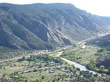
Pilar (formerly Cieneguilla) is a small unincorporated community in Taos County, New Mexico, United States. It is located on the Rio Grande.
The name comes from the Spanish word "ciénaga" which means "marsh" or "marshy place". The swampy ground is caused by several streams running across a small flood plain formed by a bend in the Rio Grande. Because the area featured a flat plain with a constant source of water, it was long frequented by the Jicarilla Apache.
In 1694, the Spaniard Diego de Vargas burned the Apache village in the process of his re-conquest of New Mexico following the expulsion of the Spanish during the Pueblo Revolt of 1680.[1]
In February 1793 the region was taken possession of by 20 persons who had received it as a land grant (Cieneguilla Grant) from the King of Spain Charles IV through his military governor in New Mexico, Don Fernando Chacón.[2]
On March 30, 1854, the battle of Cieneguilla between the Jicarilla Apache fighters and the U.S. 1st Cavalry Regiment was fought in the hills several miles from the town.
Notes
- ↑ 'New Mexico, A Guide to the Colorful State, Compiled by Workers of the Writers' Program of the Works Projects Administration in the State of New Mexico, University of New Mexico Press, Albuquerque, NM, 1945.
- ↑ Pearce, T,M, editor, New Mexico Place Names: A Geographical Dictionary, The University of New Mexico Press, 1965.
Coordinates: 36°16′11″N 105°47′15″W / 36.26972°N 105.7875°W
| |||||||||||||||||||||||
