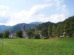
Pieve di Ledro
From Wikipedia, the free encyclopedia
| Pieve di Ledro | |
|---|---|
| Frazione | |
 | |
 Pieve di Ledro | |
| Coordinates: 45°53′N 10°44′E / 45.883°N 10.733°ECoordinates: 45°53′N 10°44′E / 45.883°N 10.733°E | |
| Country |
|
| Region | Trentino-Alto Adige/Südtirol |
| Province | Trentino (TN) |
| Comune | Ledro |
| Area(referred to the former municipality) | |
| • Total | 19.0 km2 (7.3 sq mi) |
| Population (Dec. 2004) | |
| • Total | 585 |
| • Density | 31/km2 (80/sq mi) |
| Demonym | |
| Time zone | CET (UTC+1) |
| • Summer (DST) | CEST (UTC+2) |
| Postal code | 38060 |
| Dialing code | 0464 |
Pieve di Ledro was a comune (municipality) in Trentino in the Italian region Trentino-Alto Adige/Südtirol. On January 1, 2010 it merged (with Bezzecca, Concei, Molina di Ledro, Tiarno di Sopra and Tiarno di Sotto) in the new municipality of Ledro,[1][2] as its municipal seat.
History
On July 18, 1866 the village was the theatre of a battle part of the Third Italian War of Independence. It was the prelude of the Battle of Bezzecca.
Geography
Pieve di Ledro, located about 35 km southwest of Trento, bordered with the following municipalities: Concei, Riva del Garda, Bezzecca and Molina di Ledro.
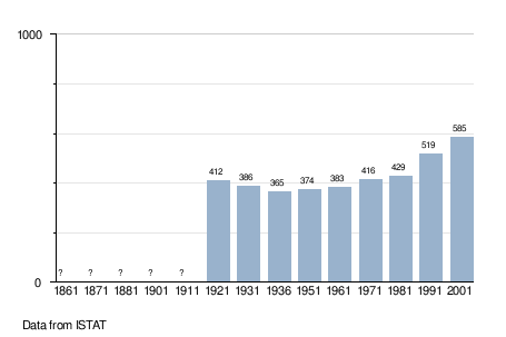
Demographic evolution
As of 31 December 2004, it had a population of 585 and an area of 19.0 km².[3]

References
External links
![]() Media related to Pieve di Ledro at Wikimedia Commons
Media related to Pieve di Ledro at Wikimedia Commons
This article is issued from Wikipedia. The text is available under the Creative Commons Attribution/Share Alike; additional terms may apply for the media files.