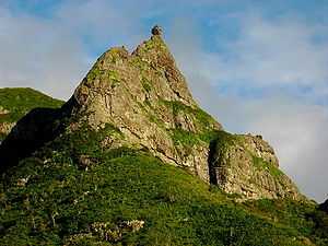
Pieter Both (mountain)

Pieter Both is the second highest mountain of Mauritius, at 820 metres tall.[1] The mountain is shorter that Piton de la Petite Rivière Noire by eight meters. It is named after Pieter Both, the first Governor-General of the Dutch East Indies. It is located in the Moka Range. The notable feature of this mountain is the gigantic rock formation at the very top of it, which resembles a human head.
To climb the mountain following the main ridge takes about an hour, and is mildly difficult. It is mainly a scramble, and being exposed, a rope is advised. The dramatic boulder on the pinnacle is about 30 feet in diameter, and has several iron spikes fixed to it to aid climbing to the top. The top is flat and about six feet across.
References
- ↑ "Review of Pieter Both mountain, Mauritius". TripAdvisor. Retrieved 27 February 2012.
Because the boulder on the top of Pieter Both overhangs the peak on which it perched it was impossible to climb on top of it. At the beginning of the twentieth century someone (I regret I cannot provide his name.) attached a light cord to an arrow and shot it over the boulder. A stronger cord was then attached to the light one and drawn over, strong enough to allow a man to hoist himself over. The steel spiked steps were then able to be punched in. They have since become very corroded and weaker than originally. In the 1940s I took my son and a group of friends there. He, and one other, were able to climb onto the boulder with their assistance although others did not dare to trust themselves to them. The local legend, at the time, was that so long as the boulder stayed perched on the top of Pieter Both the British would continue to rule Mauritius. There were rumours that by day locals would scrabble away at the shelf on which the boulder stands and at night a work gang from the Department of Public Works would be cementing it in place. It is interesting to observe that although the island has long gained independence, that boulder remains securely inplace. (Michael Alms, M.D.)
| Wikimedia Commons has media related to Category:Pieter Both, Mountain. |
Coordinates: 20°11′32″S 57°33′19″E / 20.1923°S 57.5552°E