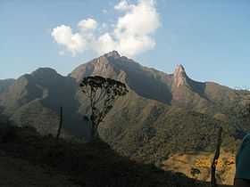
Pico dos Marins
| Pico dos Marins | |
|---|---|
 | |
| Elevation | 2,420.7 m (7,942 ft) |
| Location | |
 Pico dos Marins | |
| Range | Mantiqueira Mountains |
| Coordinates | 22°30′09″S 45°07′16″W / 22.50250°S 45.12111°WCoordinates: 22°30′09″S 45°07′16″W / 22.50250°S 45.12111°W |
| Climbing | |
| First ascent | 1911 |
Pico dos Marins is a mountain peak located on the border of two Brazilian cities: Piquete and Cruzeiro, in the state of São Paulo. The peak lies within the Mantiqueira Mountains and has an elevation of 2,420.7 metres (7,942 ft). [1]
Location
It is the highest peak located entirely within the boundaries of the state of São Paulo, for all other highest peaks are shared with Minas Gerais, for example: Pedra da Mina (2,798 metres (9,180 ft)).
Ascent
The mountain was first climbed in 1911.
Geology
The main assembly of the Marins Massif consists of three sharp rocky peaks all more than 2,000 meters high and consisting of hundreds of meters of rocky cliffs. The Pico dos Marins, although the highest, is more accessible to climbers, thanks to its less vertical north face. Deep valleys cut by canyons and tight vegetation cause its neighbors to be much more difficult to climb. North to south, the peaks are named Marins, Maria and Mariana.
References
- ↑ "Pico do Marins" (in Portuguese).