Picard (crater)
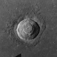
 Apollo 17 Mapping camera image | |
| Coordinates | 14°36′N 54°42′E / 14.6°N 54.7°ECoordinates: 14°36′N 54°42′E / 14.6°N 54.7°E |
|---|---|
| Diameter | 23 km |
| Depth | 2.4 km |
| Colongitude | 306° at sunrise |
| Eponym | Jean Picard |

Picard is a lunar impact crater that lies in Mare Crisium. To the west is the almost completely flooded crater Yerkes. Due east of Picard is the tiny Curtis. being slightly larger than Peirce to the north-northwest. The crater is named for 17th century French astronomer and geodesist Jean Picard.[1]
Picard is a crater from the Eratosthenian period, which lasted from 3.2 to 1.1 billion years ago. Inside Picard is a series of terraces that seismologists have attributed to a collapse of the crater floor. The lowest point on the crater floor is approximately 2000 metres below its rim.[2] T It has a small hill at the center.[3]
Satellite craters
By convention these features are identified on lunar maps by placing the letter on the side of the crater midpoint that is closest to Picard.[4]
| Picard | Latitude | Longitude | Diameter |
|---|---|---|---|
| K | 9.7° N | 54.5° E | 8 km |
| L | 10.3° N | 54.3° E | 8 km |
| M | 10.3° N | 54.0° E | 9 km |
| N | 10.5° N | 53.6° E | 20 km |
| P | 8.9° N | 53.7° E | 7 km |
| Y | 13.2° N | 60.1° E | 6 km |
The following craters have been renamed by the IAU.
- Picard G — See Tebbutt.
- Picard H — See Shapley.
- Picard X — See Fahrenheit.
- Picard Z — See Curtis.
References
- ↑ Autostar Suite Astronomer Edition. CD-ROM. Meade, April 2006.
- ↑ "Picard Crater". vgl.org. Retrieved October 18, 2007.
- ↑ Moore, Patrick (2001). On the Moon. Sterling Publishing Co.. ISBN 0-304-35469-4.
- ↑ Bussey, B.; Spudis, P., (2004). The Clementine Atlas of the Moon. New York: Cambridge University Press. ISBN 0-521-81528-2.