Pfedelbach
From Wikipedia, the free encyclopedia
| Pfedelbach | ||
|---|---|---|
| ||
 Pfedelbach | ||
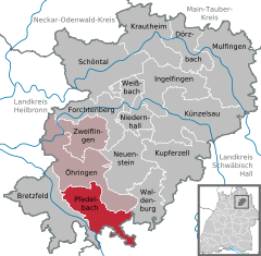
Location of Pfedelbach within Hohenlohekreis district 
 | ||
| Coordinates: 49°11′N 9°30′E / 49.183°N 9.500°ECoordinates: 49°11′N 9°30′E / 49.183°N 9.500°E | ||
| Country | Germany | |
| State | Baden-Württemberg | |
| Admin. region | Stuttgart | |
| District | Hohenlohekreis | |
| Subdivisions | 6 | |
| Government | ||
| • Mayor | Torsten Kunkel | |
| Area | ||
| • Total | 41.28 km2 (15.94 sq mi) | |
| Elevation | 240 m (790 ft) | |
| Population (2012-12-31)[1] | ||
| • Total | 8,975 | |
| • Density | 220/km2 (560/sq mi) | |
| Time zone | CET/CEST (UTC+1/+2) | |
| Postal codes | 74629 | |
| Dialling codes | 07941 | |
| Vehicle registration | KÜN | |
| Website | www.pfedelbach.de | |
Pfedelbach is a town in the district of Hohenlohe in Baden-Württemberg in Germany.
Being regionally most popular for its famous Castle (`Das Wasserschloss´ in German) built from 1568 to 1572 and the `Fürstenfaß´ (= Prince's Barrel), Pfedelbach's history dates back far into the 11th century. Nowadays most of the surrounding smaller townships have been suburbanized to this town, including Oberohrn, Heuberg/Buchhorn/Gleichen (three small villages counting as one), Harsberg, Untersteinbach and Windischenbach to name but a few.
A special aspect about the early culture of Pfedelbach is the affiliation to an ancient language called Jenisch, or Yeniche in English.
| |||||||
References
- ↑ [Statistisches Bundesamt – Gemeinden in Deutschland mit Bevölkerung am 31.12.2012 (XLS-Datei; 4,0 MB) (Einwohnerzahlen auf Grundlage des Zensus 2011) "Gemeinden in Deutschland mit Bevölkerung am 31.12.2012"]. Statistisches Bundesamt (in German). 12 November 2013.
This article is issued from Wikipedia. The text is available under the Creative Commons Attribution/Share Alike; additional terms may apply for the media files.
