Petahya
From Wikipedia, the free encyclopedia
| Petahya פְּתַחְיָה | |
|---|---|
 | |
 Petahya | |
| Coordinates: 31°52′2.63″N 34°53′14.28″E / 31.8673972°N 34.8873000°ECoordinates: 31°52′2.63″N 34°53′14.28″E / 31.8673972°N 34.8873000°E | |
| Council | Gezer |
| Region | Shephelah |
| Affiliation | HaOved HaTzioni |
| Founded | 1951 |
| Founded by | Tunisian immigrants |
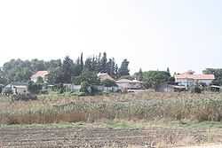
Petahya (Hebrew: פְּתַחְיָה) is a moshav in central Israel. Located in the Shephelah near Mazkeret Batya, it falls under the jurisdiction of Gezer Regional Council. In 2006 it had a population of 729.
The moshav was founded in 1951 on the land of the abandoned Arab village of al-Na'ani, whose residents had fled to the Ramallah area, Jerusalem and Jordan during the 1948 Arab-Israeli War. Initially named Gezer 10, the present name derives from "a personal name in Bible .. (I Chron. 24:16)".[1] Its founders were immigrants from the Tunisian youth movement HaNoar HaTzioni. They were later joined by immigrants from Algeria and India. Today most of its residents work in vineyards.
References
- ↑ Carta's Official Guide to Israel and Complete Gazetteer to all Sites in the Holy Land. (3rd edition 1993) Jerusalem, Carta, p.378, ISBN 965-220-186-3 (English)
Place Names in Israel. A Compendium of Place Names in Israel compiled from various sources. Translated from Hebrew, Jerusalem 1962 (Israel Prime Minister’s Office. The Israeli Program for Scientific Translations) p.223 (Location of the book: Ben Zvi Institute Library, 12 Abarbanel St., Jerusalem; in the online-catalogue: )
| Wikimedia Commons has media related to Petahya. |
| |||||||||||
This article is issued from Wikipedia. The text is available under the Creative Commons Attribution/Share Alike; additional terms may apply for the media files.