Pervijze
From Wikipedia, the free encyclopedia
| Pervijze | |
|---|---|
| Deelgemeente | |
 | |
| Coordinates: 51°04′24″N 02°47′42″E / 51.07333°N 2.79500°E | |
| Country | Belgium |
| Province |
|
| Municipality | Diksmuide |
| Area | |
| • Total | 12.23 km2 (4.72 sq mi) |
| Population (2001) | |
| • Total | 883 |
| • Density | 72/km2 (190/sq mi) |
| Source: NIS | |
| Postal code | 8600 |

Pervijze, church: parochiekerk Sint-Niklaas en Sint-Katharina
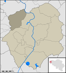
Pervijze (French: Pervyse, West Flemish: Pervyzje) is a small rural village in the Belgian province of West-Flanders, and a part ("deelgemeente") of the municipality of Diksmuide. Pervijze has an area of 12.23 km² and almost 900 inhabitants
Before the municipal mergers in 1971, Pervijze was an independent municipality. In 1971, Lampernisse, Oostkerke and Stuivekenskerke were added to the municipality. In 1977 Pervijze became a part of Diksmuide.
Pervijze was destroyed during world war I. Pervijze was situated near the Yser Front. Therefore, in Brussels (more precisely in Etterbeek), there is a street called "Rue de Pervyse" and "Pervijzestraat".
External links
Coordinates: 51°05′N 2°47′E / 51.083°N 2.783°E
This article is issued from Wikipedia. The text is available under the Creative Commons Attribution/Share Alike; additional terms may apply for the media files.