Perth Water

Perth Water is the section of the Swan River between the Causeway to the east, and Narrows Bridge to the west – a large wide but shallow section of river on the southern edge of the central business district of Perth, Western Australia, and the northern edge of the suburb South Perth.[1] It is considered a landmark of the City of Perth.
History
Historically it was much larger in size. The shorelines have been regularly changed.[2][3]
Considerable reclamation has taken place on both sides of the river. For example in 1879, landfill of Perth Water was used to create The Esplanade.[4]
Narrows bridge reclamation
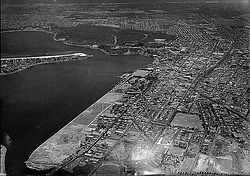
For the construction of the Narrows Bridge and its approaches, considerable amounts of the north-west section of Perth Water were reclaimed.[5][6]
The former river bank in that area is equivalent to the edge of Mounts Bay Road. The whole new Convention Centre lies on the river side of the former river bank.
Events

In 2006, the last race in the Red Bull Air Race World Series was the first held in Australia, and was held in Perth, with the competition being centred over Perth Water.[7]
It has been the annual site of Australia Day fireworks, with crowds lining the lawns and open space along the foreshores.[8] A good view for these activities has been from Kings Park due to its elevation and position looking across the Perth water area. Post-cards, calendar images, posters and photographs from most decades of the twentieth century exist, that show the view from the Park looking across Perth Water to the city.
Uses

Since the establishment of Perth, there have been either jetties or landing and mooring facilities at the location of Barrack Square at the jetty. It has had the long running Perth South Perth Transperth ferry service running across to the Mends Street Jetty which also serves Perth Zoo. Commercial companies also use the jetties for trips to Rottnest via Fremantle and Swan River wine and leisure cruises.
Ferry companies at the terminal have improved re-fuelling techniques to reduce the amount of oil pollution in Perth Water.[1]
Historical photos
The most accessible photographs that show the degradation of the space over time is in the collection in The West Australian book produced for the 150th anniversary of Western Australia in 1979.[9]
Early maps
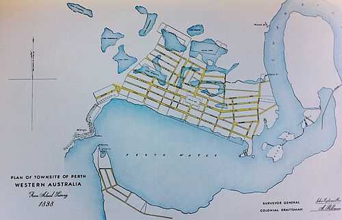
In the 1950-1951 Lord Mayor's report for the City of Perth an early map of Perth from 1838 was reproduced.[10]
Mounts Bay Road - Esplanade river edge
The earlier shore line of Perth water can be identified by the line made by Mounts Bay Road, and its extension to The Esplanade.
From some earlier photographs and images made from Kings Park it is possible to ascertain the earlier river-edges, or banks, from tree lines. The photo here is of the part of the river that was filled in to accommodate the Narrows Bridge works.

See also
- Other named parts of the Swan River:-
- Melville Water
- Reduction of water, landfill and other similar developments
- Perth waterfront development proposals
which is related or had effect upon: -
- The Esplanade (Perth)
- Elizabeth Quay
References
- ↑ 1.0 1.1 Swan River Trust – Annual Report, 1998–1999 Retrieved 29 December 2006.
- ↑ Western Australia. Public Works Dept; Palmer, Charles Stuart Russell (1903), Perth Water plan showing general scheme of proposed improvements, Public Works Dept, retrieved 26 December 2013
- ↑ Western Australia. Town Planning Dept; Western Australia. Perth Water and Burswood Island Fores hore Advisory Committee (1972), Perth water and Burswood Island foreshores outline plan of proposed foreshore uses, The Dept, retrieved 26 December 2013
- ↑ History of water use in the Perth-Bunbury region Dr Mark Lund and Helen Martin, 16 November 2005. Retrieved 29 December 2006.
- ↑ Western Australia. Government Photographer (1957), Reclaiming land for the Narrows Bridge construction, retrieved 26 December 2013
- ↑ Reclamation for Narrows Bridge, Perth, W.A. : stability and settlement considerations, 1960, retrieved 26 December 2013
- ↑ Red Bull Air Race: Swan River access restricted Department for Planning and Infrastructure. Retrieved 29 December 2006.
- ↑ LOTTERYWEST AUSTRALIA DAY SKYWORKS 2007 Lotterywest Skyworks. Retrieved 29 December 2006.
- ↑ Edmonds, Jack (editor) (1979) Swan River colony : life in Western Australia since the early colonial settlement, illustrated by pictures from an exhibition mounted by West Australian Newspapers Ltd. as a contribution to celebrations for the state's 150th year Perth: West Australian Newspapers.ISBN 0909699208 – front cover, pages 2–3, 6,7, 36,37,54,68,70,84,88 all have views of Perth water.
- ↑ Perth (W.A. : Municipality). Council (1800), The Lord Mayor's report, The Council, retrieved 4 June 2012
Coordinates: 31°57′59″S 115°51′29″E / 31.96644°S 115.85804°E