Peravia Province
| Peravia | |
| Province | |
 Salinas | |
| Country | |
|---|---|
| Capital | Baní |
| - elevation | 61 m (200 ft) |
| - coordinates | 18°17′24″N 70°19′48″W / 18.29000°N 70.33000°W |
| Area | 792.33 km2 (306 sq mi) |
| Population | 184,344 (2010) [1] |
| Density | 233 / km2 (603 / sq mi) |
| Province since | 1944 |
| Subdivisions | 2 municipalities 11 municipal districts |
| Congresspersons | 1 Senator 3 Deputies |
| Timezone | AST (UTC-4) |
| Area code | 1-809 1-829 1-849 |
| ISO 3166-2 | DO-17 |
| Postal Code | 94000 |
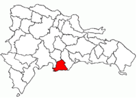 Location of the Peravia Province
| |

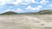
Peravia (Spanish pronunciation: [peˈɾaβja]) is a province of the Dominican Republic. Before January 1, 2002 it was included in what is the new San José de Ocoa province, and published statistics and maps generally relate it to the old, larger, Peravia. It is named after the Peravia Valley. Along the Azua Province, Peravia is characterized by its dry climate and its dunes that surround the coast. One popular attraction is the Salinas beach, which recently has grown to be a popular tourist destination with a developed town that has shops and hotels.
Municipalities and municipal districts
The province as of June 20, 2006 is divided into the following municipalities (municipios) and municipal districts (distrito municipal - D.M.) within them:[2]
|
The following is a sortable table of the municipalities and municipal districts with population figures as of the 2012 census. Urban population are those living in the seats (cabeceras literally heads) of municipalities or of municipal districts. Rural population are those living in the districts (Secciones literally sections) and neighborhoods (Parajes literally places) outside of them.[3]
| Name | Total population | Urban population | Rural population |
|---|---|---|---|
| Baní | 259,061 | 198,963 | 60,098 |
| Nizao | 39,686 | 10,548 | 29,138 |
| Peravia province | 298,747 | 209,511 | 89,236 |
For comparison with the municipalities and municipal districts of other provinces see the list of municipalities and municipal districts of the Dominican Republic.
References
- ↑ "IX Censo Nacional de Población y Vivienda 2010." (PDF) (in Spanish). Oficina Nacional de Estadística. June 2012. Retrieved 23 September 2013.
- ↑ Oficina Nacional de Estadistica, Departamento de Cartografia, Division de Limites y Linderos. "Listado de Codigos de Provincias, Municipio y Distritos Municipales, Actualizada a Junio 20 del 2006" (in Spanish). Retrieved 2007-01-24.
- ↑ Consejo Nacional de Población y Familia. "Censos y Proyecciones de la Población Dominicana por Regiones, Provincias, Municipios y Distritos Municipales, 2012" (PDF) (in Spanish). Retrieved 2010-10-11.
External links
- (Spanish) Oficina Nacional de Estadística, Statistics Portal of the Dominican Republic
- (Spanish) Oficina Nacional de Estadística, Maps with administrative division of the provinces of the Dominican Republic, downloadable in PDF format