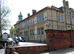
Penge Urban District
| Penge | |
|---|---|
 | |
| Area | |
| - 1911 | 770 acres (3.1 km2) |
| - 1961 | 769 acres (3.1 km2) |
| Population | |
| - 1911 | 22,330 |
| - 1961 | 25,743 |
| Density | |
| - 1911 | 29/acre |
| - 1961 | 33/acre |
| History | |
| - Origin | Detached hamlet of Battersea |
| - Created | 1866 |
| - Abolished | 1965 |
| - Succeeded by | London Borough of Bromley |
| Status |
Civil parish (1866—1965) Urban district (1900—1965) |
| Government | Penge Urban District Council (1900—1965) |
| - HQ | Town Hall, Anerley Road |
Penge was a civil parish and a local government district located to the southeast of London, England. It included the settlements of Penge, Anerley and part of Crystal Palace. It was part of the London postal district, Metropolitan Police District and, from 1933, the London Passenger Transport Area.
Penge was a detached hamlet of the ancient parish of Battersea in the Brixton hundred of Surrey.[1][2] Battersea became part of the area administered by the Metropolitan Board of Works in 1855 and the main part of the parish was grouped into the Wandsworth District whilst Penge became part of the Lewisham District. In 1866 it became a civil parish in its own right, forming part of the County of London from 1889.
In 1900 the local government arrangements in the County of London were reformed by the London Government Act 1899. Provision was made for Penge to be combined with either the Metropolitan Borough of Camberwell or the Metropolitan Borough of Lewisham in the County of London, or to form an urban district in the counties of Surrey or Kent. The County Borough of Croydon would have made it an exclave of the administrative county of Surrey, and in the event it was transferred to Kent as an urban district.[3]
In 1965 the urban district was abolished by the London Government Act 1963 and its former area was transferred to Greater London, to be combined with that of other districts to form the present-day London Borough of Bromley.[3]
References
- ↑ Vision of Britain - Battersea CP (historic map)
- ↑ British History Online - Battersea with Penge Hamlet
- ↑ 3.0 3.1 Vision of Britain - Penge UD (historic map)
| |||||||||||||||||||||||||
Coordinates: 51°25′N 0°4′W / 51.417°N 0.067°W
