Patilla Pata
From Wikipedia, the free encyclopedia
| Patilla Pata | |
|---|---|
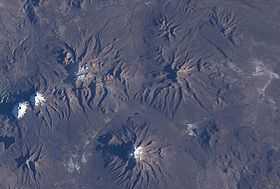
 Patilla Pata is located NW of Nevado Sajama (this latter is in the lower center of this NASA image, with north to the top right corner). | |
| Elevation | 5,300 m (17,388 ft) |
| Location | |
| Location | Bolivia |
| Range | Andes |
| Coordinates | 18°3′0″S 69°2′0″W / 18.05000°S 69.03333°W |
| Geology | |
| Type | Stratovolcano |
| Last eruption | Unknown |
Patilla Pata is a stratovolcano in Bolivia. The date of its last eruption is unclear, but it is unlikely to be during the Holocene as the mountain is heavily glaciated. The composition of the volcano is largely andesitic, but there are also a number of basaltic lava flows.
See also
- Jach'a Kunturiri
- Laram Q'awa
- Sajama
- List of volcanoes in Bolivia
Sources
- Siebert L, Simkin T (2002-). Volcanoes of the World: an Illustrated Catalog of Holocene Volcanoes and their Eruptions. Smithsonian Institution, Global Volcanism Program Digital Information Series, GVP-3, (http://www.volcano.si.edu).
This article is issued from Wikipedia. The text is available under the Creative Commons Attribution/Share Alike; additional terms may apply for the media files.