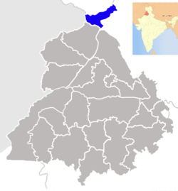
Pathankot district
| Pathankot district ਪਠਾਣਕੋਟ ਜ਼ਿਲ੍ਹਾ | |
|---|---|
| District | |
 | |
| Coordinates: 32°16′01″N 75°38′36″E / 32.266814°N 75.643444°ECoordinates: 32°16′01″N 75°38′36″E / 32.266814°N 75.643444°E | |
| Country |
|
| State | Punjab |
| District | Pathankot |
| Named for | Pathania Rajputs fortress |
| Headquarters | Pathankot |
| Languages | |
| • Official | Punjabi (Gurmukhi) |
| • Regional | Punjabi |
| • Other | English |
| Time zone | IST (UTC+5:30) |
| Vehicle registration | PB35 |
Pathankot district (Punjabi: ਪਠਾਣਕੋਟ ਜ਼ਿਲ੍ਹਾ), is a district of Indian Punjab, located in the north zone of the state. Pathankot city is the district headquarters. The district was created on 27 July 2011.
Geography
It is located in the foots of Sivalik Hills. It shares international borders with the Narowal District of Pakistani Punjab. Its also shares borders with the Kathua District of Jammu and Kashmir and Chamba District and Kangra District districts of Himachal Pradesh. Hoshiarpur district shares boundary with this in Eastern Punjab. The two main rivers, Beas and Ravi, passes through the district.
History
Pathankot was the capital of Nurpur princely state ruled by the Pathania Rajputs. In Mughal records it was known as Paithan an abbreviation of Pratishthan from which the Pathania Rajputs derive their name, an ancient customed tradition of Rajputs, in which the King almost in all instances took his name from the name of the country where he exercised his dominion. The capital was shifted from pathankot to dhameri Nurpur in the time of Raja Basu Dev (1580-1613).[1][2]
The Kanhaiya Misl, one of the twelve Sikh Misls, ruled this area from about 1781-1796 until Ranjit Singh of Gujranwala, took the area, and it remained part of the Sikh Kingdom until 1849, until it's annexation to the British Dominion. The villages of Dhariwal, and Japuwal, and Gurdas Nangal, all In tehsil Pathankot, are very closely related to Sikh history.
The district today
It was located in the Gurdaspur district then. The present district is formed, as the 22nd district of the state, on 27 July 2011.[3][4] It includes the two sub-divisions of Pathankot and Dhar Kalan and two sub-tehsils of Naraut Jaimal Singh and Bamial.[4] The headquarters is Pathankot and comprise 421 revenue villages.
References
| Wikimedia Commons has media related to Pathankot district. |
- ↑ The Princely and Noble Families of the Former Indian Empire: Himachal Pradesh V. 1 By Mark Brentnall, Indus Publishing, p. 350
- ↑ History of the Panjab Hill States By J. Hutchison, J.P. Vogel, Asian Educational Services, p. 213
- ↑ Naveen S. Garewal (27 July 2011). "Eye on urban voter, Fazilka, Pathankot made districts". The Tribune, Chandigarh. Retrieved 23 January 2012.
- ↑ 4.0 4.1 News services (28 July 2011). "The state gets Fazilka and Pathankot districts". Indian Express. Retrieved 23 January 2012.
| ||||||||||||||||||||
