Pathankot
| Pathankot ਪਠਾਣਕੋਟ یتھانکوٹ | |
|---|---|
| City | |
 | |
 Pathankot | |
| Coordinates: [//tools.wmflabs.org/geohack/geohack.php?pagename=Pathankot¶ms=32.266814_N_75.643444_E_type:city(253987)_region: 32°16′01″N 75°38′36″E / 32.266814°N 75.643444°E]Coordinates: [//tools.wmflabs.org/geohack/geohack.php?pagename=Pathankot¶ms=32.266814_N_75.643444_E_type:city(253987)_region: 32°16′01″N 75°38′36″E / 32.266814°N 75.643444°E] | |
| Country |
|
| State | Punjab |
| Elevation | 331 m (1,086 ft) |
| Population (2011) | |
| • Total | 253,987 |
| Languages | |
| • Official | Punjabi |
| Time zone | IST (UTC+5:30) |
| PIN | 145001 |
| Telephone code | 0186 |
| Vehicle registration | <PB35> |
Pathankot is a municipal corporation in the Indian state of Punjab, and serves as the capital of the Pathankot district. The name Pathankot comes from Pathania Rajput, who was the king of Nurpur. Pathankot was the capital of Nurpur prior to 1849. Pathankot is at the meeting point of the three northern states of Punjab, Himachal Pradesh and Jammu and Kashmir. Due to its ideal location, Pathankot serves as a travel hub for the three northerly states. Pathankot is the eighth most populous city in the state of Punjab. It is the last city in Punjab on the national highway towards Jammu and Kashmir. Situated in the foothills of Kangra and Dalhousie, with the river Chakki flowing close by, the city is often used as a rest-stop before heading into the mountains of Jammu and Kashmir, Dalhousie, Chamba, and Kangra, deep into the Himalayas.
History of Pathankot and Pathania Rajput
Pathankot was the capital of Nurpur, a princely state, ruled by the Pathania Rajputs. In Mughal records it was known as Paithan, an abbreviation of Pratishthan from which the Pathania Rajputs derive their name. Pathania is the name of the branch of the Tomara Clan of Chandravanshi, Rajputs, who claim a mythological descent from Arjuna, the hero of Mahabharata. They mostly live in and around Himachal Pradesh, in North India. It was an ancient traditional custom of the Rajputs for the king, almost in all instances, to take his name from the name of the country where he exercised his dominion. The capital was shifted from Pathankot to Dhameri Nurpur during the reign of Raja Basu Dev 1580–1613.[1][2]
Brief history of Pathania Rajput
Rana Jethpal (1100?), the younger brother of King Anangpal II of Delhi, came to Jallandhar Doab (also called Bist Doab) to conquer a territory for himself. After crossing the Beas river he captured a fort called Bhet, therefore acquiring the name Rana Bhet. After this he came upon the city of Pathankot (possibly ancient Pratisthana), and following the tradition of Rajputs, in which the king typically took his name from the name of the country where he exercised his dominion, he became known as a Pathania Rajput, instead of as a Tomara.
The Kingdom of Nurpur had its capital at Pathankot, now a district of Punjab, India. The kingdom included Pathankot and a large tract on the plains of the Punjab; also the whole of the present Nurpur Tahsil of Kangra district of Himachal Pradesh, with the addition of Shahpurkandi, now in Gurdaspur, and also a small tract to the west of the Ravi, called Lakhanpur, now in Jammu & Kashmir State. The Kingdom was bounded on the north by Kangra and Chamba, on the south by the Punjab plains, and on the west by the Ravi river. The Capital was at Pathankot, which was known as Paithan in the medieval times. Throughout their history the Pathania clan rebelled against the foreign invaders. Though the Pathania kings sometimes held the high offices of generals known as Mansabdar in the Mughal military, and captured many a kingdom for the Mughal Emperor in Hindustan and beyond the Indus up till Uzbekistan. Yet, they repeatedly rebelled against the Mughal's and other foreign invaders. The most popular uprising was by Wazir Ram Singh Pathania who led a rebellion against the British Raj and was subsequently defeated by the British after a hard-fought battle. He was deported to Rangoon where he died in prison. Locals still sing ballads for their brave warrior, and a statue commemorating his deeds was erected on Pathankot Punjab-Dalhousie Himachal Highway.
Raja Jagat Singh Pathania
Raja Jagat Singh Pathania (1618–1646) succeeded Raja Suraj Mal (his elder brother) as the King of Nurpur, Himachal/India. He was the second son of Raja Basu Dev. The golden period of Pathania rule on Nurpur (then Dhameri) came under the reign of Raja Jagat Singh. Raja Jagat Singh ruled until 1644 and during his reign rendered assistance to Mughal forces in Qandhar, Kabul.
Shahpur kandi fort
The Shahpurkandi fort is one of the main attractions of Pathankot city. It was built in 1505 by Jaspal Singh Pathania, a Rajput chief. It was strategically located to have control over the Kangra and Nurpur region. The fort is in ruins, and is famous for its temples and the view it commands over the Ravi river.
Geography
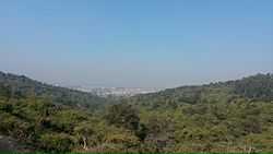
Pathankot has an average elevation of 332 metres (1,089 ft). It is a green town surrounded by the Ravi and Chakki rivers. Shiwalik foothills on the south and east and snow capped Himalayas in the back drop in north.
Average temperature
- Spring: The climate remains the most enjoyable part of the year during the spring season (from mid-February to mid-April). Temperatures vary between (max) 16 °C to 25 °C and (min) 9 °C to 18 °C.
- Autumn: In autumn (from Mid-September to mid November.), the temperature may rise to a maximum of 30 °C. Temperatures usually remain between 16° to 27° in autumn. The minimum temperature is around 11 °C.
- Summer: The temperature in summer (from Mid-May to Mid-June) may rise to a maximum of 48 °C (rarely). Temperatures generally remain between 35 °C to 45 °C (94 – 112F).
- Monsoon: During monsoon(from mid-June to mid-September), Pathankot receives moderate to heavy rainfall and sometimes heavy to very heavy rainfall (generally during the month of August or September). Usually, the rain bearing monsoon winds blow from south-west/ south-east. Mostly, the city receives heavy rain from south (which is mainly a persistent rain) but it generally receives most of its rain during monsoon either from North-west or North-east. Maximum amount of rain received by the city of Pathankot during monsoon season is 195.5 mm in a single day.
- Winter: Winters (November to Mid-March) are mild but it can sometimes get quite chilly in Pathankot. Average temperatures in the winter remain at (max) 7 °C to 15 °C and (min) 0 °C to 8 °C. Rain usually comes from the west during winters and it is usually a persistent rain for 2–3 days with sometimes hail-storms. Pathankot received snowfall in 2012 after almost 55 years.
Economy
Pathankot is an economically prosperous city compared to many other towns of the Punjab or Himachal Pradesh.
Historically, Pathankot's economy was based upon the timber trade. Good quality wood was transported from Himachal to Pathankot, where it was cut and distributed to various parts of northern India. In the early 1990s, however, the timber trade shifted to Jammu. Now, the main economy of Pathankot is based on stone crushing. Panthakot is situated in the foothills where the Chakki, Ravi and Beas rivers enter the plains and these rivers deposit boulders. There are more than 200 stone crushers in and around Pathankot.[citation needed]
After the liberalisation of the Indian economy, Pathankot emerged as a commercial center of wholesalers and distributors of consumer goods and services, catering to Himachal Pradesh, J&K and northwest Punjab.
Demographics
As per provisional data of 2011 census Pathankot urban agglomeration had a population of 159,909, out of which males were 84,145 and females were 75,764. The literacy rate was 88.71 per cent.[3]
Defence Forces
Pathankot is one of the main cantonments in Western Command of Indian Army. The city serves as the HQ of 45th Cavalry Regiment and 29th Infantry Division. Most of the area is occupied by Defence only. The city also has presence of Indian Air Force and is one of the biggest Air Bases in India. The commercial flights that land in Pathankot also use the Defence Air Base. It is heavily guarded as many squadrons are located here. The airport lies inside the IAF cantonment. The city and Air Base were severely affected in the Indo-Pakistani Air War of 1965.
Landmarks
Places worth visiting near Pathankot include Shahpur Kandi with a hanging rest house, Ranjit Sagar Dam which is the highest gravity dam in Asia. Madhopur head works which date back to the Mughal era. head works of Upper Bari Doab, Shahpur Kandi are the attractions of this area. Another place of interest could be Keshopur Chhamb which is home to many Migratory Birds
Dhruva park has been donated to the city by 21 sub Area of Indian army.
India's foremost hydraulic research stations is situated at Malikpur which is 7 km from Pathankot, where various models of Dams and Irrigation Canals are made before actual work starts upon them.
Transport
The airport of Pathankot is jointly shared by defence and civilians and is the glory of this district. Maharana Partap Interstate bus terminal is one of the biggest terminals of North India. Pathankot city is one of the rarest cities in North India, having 4 railway stations of its own, with Pathankot Junction station under A-category.
One can stop over in Pathankot en route to Mukerian (40), Dharamshala (100 km), Dalhousie (100 km), Amritsar (108), Palampur (100 km), Chamba (100 km) & Jammu (100 km), Hoshiarpur (100 km), Kangra (100 km), Jalandhar (108 km), Srinagar (400 km) all in different directions from Pathankot via Jalandhar-Srinagar National highway (NH-1A), Dabwali-Pathankot National highway (NH-54) and Pathankot-Mandi National highway (NH-20).
Airport
- Pathankot Airport
- Mamoon Helipad
Railway
- Pathankot Jn.
- Pathankot Cantt.(chakki bank)
- Bharoli Jn.
- Dalhousie Road
- Sarna Station
The town is the lower terminus of the narrow gauge Kangra Valley Railway, thereby connecting the mountainous regions of western Himachal Pradesh to the network of Indian Railways.
References
- ↑ The Princely and Noble Families of the Former Indian Empire: Himachal Pradesh V. 1 By Mark Brentnall, Indus Publishing, p. 350
- ↑ History of the Panjab Hill States By J. Hutchison, J.P. Vogel, Asian Educational Services, p. 213
- ↑ "Urban Agglomerations/Cities having population 1 lakh and above". Provisional Population Totals, Census of India 2011. Retrieved 7 July 2012.