Pari Chata
From Wikipedia, the free encyclopedia
| Pari Chata | |
|---|---|
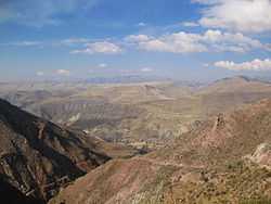
 Cordillera de los Frailes, looking west. Pari Chata is on the right in the background, left of it is the Pillku Mayu valley. | |
| Elevation | 4,704 m (15,433 ft) |
| Location | |
 Pari Chata | |
| Location | Bolivia, Potosí Department, Tomás Frías Province |
| Range | Andes |
| Coordinates | 19°19′S 66°0′W / 19.317°S 66.000°WCoordinates: 19°19′S 66°0′W / 19.317°S 66.000°W |
Pari Chata, also spelled Parichata, (Aymara pari red hot,[1] Pukina chata mountain,[2] "red hot mountain") is a mountain in the Andes in Bolivia, about 4,704 m (15,433 ft) high. It is located in the Cordillera de los Frailes in the Potosí Department, Tomás Frías Province, Yocalla Municipality,[3] north of the river Pillku Mayu ("red river").
See also
References
- ↑ www.katari.org Aymara-Spanish dictionary: Pari (s.) - Candente, objecto calentado al máximo.
- ↑ Teofilo Laime Ajacopa, Lengua Pukina en Jesús de Machaca, referring to Alfredo Torero ("Reflexión acerca del pukina escrito por Alfredo Torero ... Pukina <Chata> - Castellano Cerro - Palabras relacionadas en aymara Qullu") (English: mountain)
- ↑ Yocalla Municipality: population data and map showing Pari Chata ("Parichata")
| ||||||||||||||
This article is issued from Wikipedia. The text is available under the Creative Commons Attribution/Share Alike; additional terms may apply for the media files.
