Paqu Quta
From Wikipedia, the free encyclopedia
| Paqu Quta / P'aqu Quta | |
|---|---|
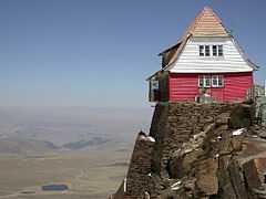
 A view of Paqu Quta and El Alto in the distance from Chacaltaya refuge | |
| Location |
La Paz Department, Pedro Domingo Murillo Province |
| Coordinates | 16°23′S 68°8′W / 16.383°S 68.133°WCoordinates: 16°23′S 68°8′W / 16.383°S 68.133°W[1] |
| Surface elevation | 4,667 m (15,312 ft) |
Paqu Quta, also spelled P'aqu Quta, (Aymara paqu / p'aqu light brown, reddish, fair-haired, dark chestnut,[2] quta lake,[3] "chestnut coloured lake") is a lake in Bolivia located in the La Paz Department, Pedro Domingo Murillo Province, El Alto Municipality.[4] It is situated at a height of about 4,667 metres (15,312 ft) south of Mount Chacaltaya, south east of Lake Milluni and south west of Qillwani (Khelluani).
Gallery
-

Paqu Quta (in the background on the right) as seen from the north
-
Paqu Quta as seen from the Chacaltaya Astrophysical Observatory
See also
- Janq'u Quta (El Alto)
- Janq'u Quta (La Paz)
- Laram Quta
- Pata Quta
External links
- El Alto Municipality: population data and map showing Wila Quta situated south east of Lake Milluni and south west of Khelluani
References
- ↑ mapcarta.org "Laguna Vilacota"
- ↑ aymara.ucb.edu.bo CAFÉ claro. Bermejo, ja. // Pelirrubio, bia. De pelo rubio. // Castaño obscuro. adj. Paqu, p'aqu, chuchi, millu.
- ↑ www.katari.org Quta (s.) - Lago.
- ↑ summitpost.org Map of the area showing this lake named "Paku Quta"
This article is issued from Wikipedia. The text is available under the Creative Commons Attribution/Share Alike; additional terms may apply for the media files.
