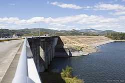
Pantabangan Dam
| Pantabangan Dam | |
|---|---|
 Behind the dam's spillway | |
.svg.png) | |
| Coordinates | 15°48′52″N 121°06′29″E / 15.81444°N 121.10806°ECoordinates: 15°48′52″N 121°06′29″E / 15.81444°N 121.10806°E |
| Construction began | June 1971 |
| Construction cost | $ 20.74 Million or 891.82 Million pesos (at current price) |
| Owner(s) |
National Power Corporation National Irrigation Administration |
| Dam and spillways | |
| Spillway capacity | 4,200 m3/s (148,322 cu ft/s) |
| Power station | |
| Commission date | 1977 |
Pantabangan Dam is an earth-fill embankment dam on the Pampanga River located in Pantabangan in Nueva Ecija province of the Philippines. The multi-purpose dam provides water for irrigation and hydroelectric power generation while its reservoir, Pantabangan Lake, affords flood control. The reservoir is considered one of the largest in Southeast Asia and also one of the cleanest in the Philippines. Construction on the dam began in 1971 and it was complete in 1977.
History
In May 1969, the Congress of the Philippines authorized the development of the Pampanga Basin with Republic Act No. 5499. In October of that year, detailed studies of the Pantabangan site were carried out and lasted two years.[1] By June 11, 1971, Pantabangan was an old town of around 300 years old. President Ferdinand Marcos and many others arrived for a ground breaking ceremony in Palayupay, Pantabangan, Nueva Ecija, to signal the beginning of the construction of Pantabangan Dam.[2] The dam went into operation in February 1977 and was completed later in May.[1] Approximately 1,300 people were relocated from the dam's reservoir zone.[3]
Design
The dam is a 107 m (351 ft) tall and 1,615 m (5,299 ft) long embankment-type with 12,000,000 cu yd (9,174,658 m3) of homogeneous earth-fill and an impervious core. The crest of the dam is 12 m (39 ft) wide while the widest part of its base is 535 m (1,755 ft). The dam's crest sits at an elevation of 232 m (761 ft) and is composed of three sections: the main dam, a saddle dam, and an auxiliary dam located with the spillway. The spillway is a chute-type controlled by three radial gates but equipped with an overflow section as well. The design discharge of the spillway is 4,200 m3/s (148,322 cu ft/s). The dam's reservoir has a gross capacity of 2,996,000,000 m3 (2,428,897 acre·ft) and 2,083,000,000 m3 (1,688,716 acre·ft) of that volume is active (or useful) for irrigation and power. The dam sits at the head of a 853 km2 (329 sq mi) catchment area and its reservoir has a surface area of 69.62 km2 (27 sq mi) and elevation of 230 m (755 ft) when at its maximum level. The reservoir's life is estimated at 107 years due to silt from denudation.[1] The dam was design to withstand an intensity 10 earthquake.[4]
The power house is located at the base of the main dam and contains two 50 MW Francis turbine-generators for an installed capacity of 100 MW. Each turbine receives water via a 6 m (20 ft) diameter penstock. When the water is discharged, it is released into a 250 m (820 ft) long tailrace channel where it re-enters the river.[1]
References
- ↑ 1.0 1.1 1.2 1.3 "Pantabangan Dam". Database of Water-Related Projects in The Republic of the Philippines. Retrieved 4 November 2011.
- ↑ "PANTABANGAN DAM". Retrieved 2011-11-03.
- ↑ McDowell, ed. by Christopher (1996). Understanding impoverishment : the consequences of development induced displacement (1. publ. ed.). Providence, RI [u.a.]: Berghahn. p. 170. ISBN 1-57181-916-9.
- ↑ Cervantes, Ding (13 April 2011). "NIA: Pantabangan Dam can withstand Intensity 10 quake". The Philippine Star. Retrieved 4 November 2011.
| |||||