Pakse
| Pakse ປາກຊັນ | |
|---|---|
| City | |
 | |
 Pakse | |
| Coordinates: 15°07′N 105°47′E / 15.117°N 105.783°E | |
| Country |
|
| Province | Champasak Province |
| District | Pak Sé District |
| Population | |
| • Total | 87,000 |
| • Religions | Buddhism |
Pakse or Pakxe (French Paksé; Laotian ປາກເຊ [pȁːk séː] "Mouth of the river Se") is the capital and most populous city in the southern province of Champasak, making it the third most populous city in Laos. It has a population of about 87,000,[1] situated at the confluence of the Xe Don and Mekong Rivers. It also served as the capital of the Kingdom of Champasak until it was unified with the rest of Laos in 1946.
History
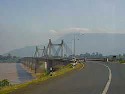
This city was founded by the French as an administrative outpost in 1905, and was formerly the capital of the Lao Kingdom of Champasak until its abolishment in 1946 when the Kingdom of Laos was formed. During the Franco-Thai war the French ceded Pakse to the Thai authorities. The city served as the primary seat and residence to Prince Boun Oum Na Champassak, an important figure in the Laotian Civil War. He built Champasak Palace but fled in 1974 before it was completed. In May 1975, it fell to Pathet Lao forces. Since 1975, Pakse has become an economic power and of regional importance within the region. The construction of a bridge over the Mekong (built with Japanese aid), allowing road traffic with Ubon Ratchathani in Thailand, has further integrated the city with neighbouring countries.
Demographics
Pakse is home to many ethnic Chinese and Vietnamese people.
Religion
The city population predominately practices Buddhism but has a Catholic church.
Culture
The city has the Champasak Provincial Museum, which holds historical documents and artifacts of the province.
Infrastructure
Health
There are two hospitals located within the city, one is the second biggest of Laos, but many citizens travel across the border to Thailand to receive better treatment, as they are better equipped.[2] There is a high risk of malaria and dengue fever during the monsoon season.
Transportation
Road
Pakse is located along National Road 13, the main transportation highway of Laos. It has the bridges over the Xe Don, the French and the Russian Bridge, and one bridge over the Mekong River, the Lao Nippon Bridge, only one of five bridges over the Mekong in Laos. Pakse is the gateway to the Bolaven Plateau, as well as to the southern provinces of Salavan, Sekong and Attapeu.
Air
It is served by Pakse International Airport. The Pakse airport finished construction on November 2, 2009, resuming flights to Vientiane, Siem Reap, Ho Chi Minh City and Bangkok.
Climate
Pakse has a tropical savanna climate (Köppen climate classification Aw) with very warm temperatures throughout the year. Temperatures are especially high in the months before the monsoon season (March-April). There is a distinct wet season (April-October) and dry season (November-March).
| Climate data for Pakse | |||||||||||||
|---|---|---|---|---|---|---|---|---|---|---|---|---|---|
| Month | Jan | Feb | Mar | Apr | May | Jun | Jul | Aug | Sep | Oct | Nov | Dec | Year |
| Average high °C (°F) | 31.0 (87.8) |
32.7 (90.9) |
34.4 (93.9) |
34.8 (94.6) |
32.9 (91.2) |
31.0 (87.8) |
30.4 (86.7) |
30.1 (86.2) |
30.3 (86.5) |
30.8 (87.4) |
30.5 (86.9) |
30.2 (86.4) |
31.59 (88.86) |
| Daily mean °C (°F) | 23.2 (73.8) |
27.0 (80.6) |
29.7 (85.5) |
29.3 (84.7) |
28.1 (82.6) |
26.7 (80.1) |
26.7 (80.1) |
26.5 (79.7) |
27.3 (81.1) |
26.3 (79.3) |
25.5 (77.9) |
22.4 (72.3) |
26.56 (79.81) |
| Average low °C (°F) | 16.3 (61.3) |
21.4 (70.5) |
24.5 (76.1) |
24.9 (76.8) |
24.9 (76.8) |
23.9 (75) |
24.1 (75.4) |
24.3 (75.7) |
23.7 (74.7) |
22.9 (73.2) |
22.4 (72.3) |
19.7 (67.5) |
22.75 (72.94) |
| Precipitation mm (inches) | 2.0 (0.079) |
7.9 (0.311) |
19.8 (0.78) |
75.7 (2.98) |
223.1 (8.783) |
420.0 (16.535) |
383.2 (15.087) |
523.9 (20.626) |
297.5 (11.713) |
99.6 (3.921) |
19.3 (0.76) |
2.8 (0.11) |
2,074.8 (81.685) |
| Avg. rainy days | 0 | 1 | 2 | 7 | 15 | 21 | 22 | 25 | 13 | 12 | 10 | 0 | 128 |
| % humidity | 62 | 60 | 59 | 65 | 75 | 82 | 83 | 85 | 84 | 79 | 72 | 67 | 72.8 |
| Mean monthly sunshine hours | 278.0 | 247.3 | 285.6 | 221.5 | 218.3 | 136.2 | 145.2 | 125.5 | 160.6 | 193.6 | 225.5 | 258.9 | 2,496.2 |
| Source: NOAA (1961-1990) [3] | |||||||||||||
Tourism
Pakse is growing as a tourist destination with tourist arrivals doubling over the past decade, from 53,000 in 2002 to over 111,000 in 2008.[1] Sites of interest include:
- Wat Phu
- Si Phan Don
References
| Wikimedia Commons has media related to Pakxe. |