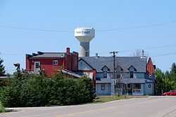
Pain Court, Ontario
| Pain Court | |
|---|---|
| Unincorporated community | |
 | |
| Coordinates: 42°24′35″N 82°18′30″W / 42.40972°N 82.30833°W | |
| Country |
|
| Province |
|
| Municipality | Chatham-Kent |
| Settled | 1780s |
| Time zone | EST (UTC-5) |
| • Summer (DST) | EDT (UTC-4) |
| Forward sortation area | N0P 1Z0 |
| Area code(s) | 519 and 226 |
| NTS Map | 040J08 |
| GNBC Code | FDISB |

Pain Court (often incorrectly spelled Paincourt), is an agricultural village in southwestern Ontario, Canada, in the municipality of Chatham-Kent. It was established in 1854, as one of the earliest French-speaking settlements in southern Ontario. Pain Court was founded when English and French-speaking squatters from the Detroit, Michigan, area began to settle the Indian lands along the lower Thames River in the region in the 1780s. It derived its name from the small loaves of bread which the impoverished parishioners offered to Roman Catholic missionaries.[1]
By the 1820s in the nearby "Pain Court Block", one of the earliest French-speaking (franco-ontarian) communities in southern Ontario had developed. Named Pain Court (literally meaning "short bread") by Catholic missionaries in reference to the small loaves of bread which was all the impoverished parishioners could offer, the settlement was surveyed in 1829. In 1852 a chapel was built and two years later construction of a church commenced. It quickly became the cultural and educational centre of French-speaking Catholics in the area. By 1866 when a post office was established, a small village had developed.[2]
Joseph Caron, the former Canadian High Commissioner to India, was raised in Pain Court.
Education
Pain Court has an elementary and a secondary French-language (francophone) school. École Sainte-Catherine is a very small elementary school located directly across the street from its sister school, École secondaire de Pain Court, a small high school with approximately 200 students.[3]
Wildlife
Just west of Pain Court, on the shores of Lake St. Clair, an Environment Canada National Wildlife Area (St. Clair NWA) provides a variety of migrating birds with wetland habitat of international importance. It is one of only 51 such sites in Canada.[4]
References
External links
- Pain Court 150
- Ontario Heritage Trust / Pain Court
- Historic Plaque of Pain Court
- Ecole secondaire de Pain Court / Pain Court Secondary School
- Pain Court Catholic Parish - Immaculate Conception
- St. Clair National Wildlife Area
- Club de l'amitié de Pain Court et Club d'âge d'or
- Cultural Group for Chatham-Kent francophones La Girouette
- Franco-ontarian women's group for Windsor and Pain Court
- Pain Court at Geographical Names of Canada
Coordinates: 42°24′35″N 82°18′30″W / 42.40972°N 82.30833°W