Ozoir-la-Ferrière
From Wikipedia, the free encyclopedia
| Ozoir-la-Ferrière | |
|---|---|
 | |
| Coordinates: 48°46′41″N 2°40′48″E / 48.778°N 2.68°ECoordinates: 48°46′41″N 2°40′48″E / 48.778°N 2.68°E | |
| Country | France |
| Region | Île-de-France |
| Department | Seine-et-Marne |
| Arrondissement | Torcy |
| Canton | Roissy-en-Brie |
| Government | |
| • Mayor (2008–incumbent.) | Jean-François Oneto |
| Area | |
| • Land1 | 15.58 km2 (6.02 sq mi) |
| Population (2006) | |
| • Population2 | 20,463 |
| • Population2 Density | 1,300/km2 (3,400/sq mi) |
| INSEE/Postal code | 77350 / 77330 |
| Elevation | 94–122 m (308–400 ft) |
|
1 French Land Register data, which excludes lakes, ponds, glaciers > 1 km² (0.386 sq mi or 247 acres) and river estuaries. 2 Population without double counting: residents of multiple communes (e.g., students and military personnel) only counted once. | |
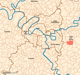
Ozoir-la-Ferrière is a commune in the Seine-et-Marne department in the Île-de-France region in north-central France. It is located in the urban area of Paris 25.6 km (15.9 mi) east-southeast from the center.
Demographics
Inhabitants are called Ozoiriens or Ozophoriciens.
History
During the French Revolution, Ozoir-la-Ferrière was temporarily renamed Ozoir-la-Raison, meaning "Ozoir the Reason".
Transportation
Ozoir-la-Ferrière is served by Ozoir-la-Ferrière station on Paris RER line ![]() .
.
Twin cities
Ozoir-la-Ferrière is twinned with the city of Swords, the county town of Fingal, in eastern Ireland.
See also
References
External links
- Official website (French)
- 1999 Land Use, from IAURIF (Institute for Urban Planning and Development of the Paris-Île-de-France région) (English)
- French Ministry of Culture list for Ozoir-la-Ferrière (French)
| |||||
This article is issued from Wikipedia. The text is available under the Creative Commons Attribution/Share Alike; additional terms may apply for the media files.