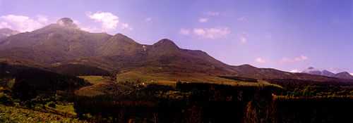
Outeniqua Mountains

The Outeniqua Mountains form a mountain range located along the Garden Route of South Africa. They run parallel to the coast and form a continuous range with the Langeberg to the west and the Tsitsikamma Mountains to the east. The range was named "Serra da Estrela" ('Mountain of the Star') on old Portuguese charts.
Nomenclature
'Outeniqua' is said to be derived from a Khoisan tribe that once lived in these mountains and means "they who bear honey"."[1] Rock paintings from the Khoisan people can still be found in the area.[1]
Geography
The range is characterized by gentle southern slopes and steep drops on the north side down to the low valley Little Karoo.[2] High points include Cradock Peak at 1578 m and George Peak at 1370 m located to the north of George. The varying conditions create diverse habitats. On the south-facing slopes there is montane fynbos at higher, moister altitudes, while the north hosts karroid and renosterveld shrubland. On the mesic southern slopes there are Afromontane gallery forests.
Weather
The high rainfall on the range has created numerous perennial streams used for irrigation in the Olifants River valley. While the climate along the range is generally hot to moderate, with an average summer temperature of 20.5 °C[citation needed], weather conditions can vary greatly. In winter the temperature can drop to 5 °C (and even lower on the southern slopes) and snowfalls may occur on the higher peaks.
Fauna and flora
Among the animals found in the Outeniqua range are klipspringer, grey rhebuck, leopard and various rodents.[1] The Outeniqua mountain range is also home to a very small number of African elephants. Although described as functionally extinct, new sightings of these very elusive animals, including that of a young bull [3] give hope that the fabled animals might with time become re-established in the Outeniqua reserve. Birds include black eagles and other raptors as well as the Cape sugarbird and other fynbos birds.[1]
Passes
In 1908 work started on a railway route over the range from George to Oudtshoorn. This required the building of seven tunnels and numerous long cuttings. The line was opened in August 1913.
The first road pass to cross the range into the Langkloof went via Duiwelskop, some 32 km east of George. In 1811 a new pass was constructed and named Cradock Pass after the Governor, Sir John Cradock. It was difficult to negotiate and became known as the 'Voortrekker Road'. In 1847 a vastly improved Montagu Pass was constructed by convict labour, and named after the Colonial Secretary, John Montagu. In 1943, to cope with the increasing demands of modern traffic, construction was started on the Outeniqua Pass, using the labour of Italian prisoners of war. At the end of World War II the Italians returned home with the greater part of the pass unfinished. The pass was opened to traffic in September 1951, having cost approximately £500 000.
Two other road passes cross the Outeniqua - The Robinson Pass west of George, and Prince Alfred's Pass connecting Uniondale with Knysna.
Historic incidents
On 1 June 2002, Former South Africa Cricket captain Hansie Cronje scheduled flight home from Johannesburg to George, Western Cape was grounded so he hitched a ride as the only passenger on board a Hawker Siddeley HS 748 turboprop aircraft. Near George airport, the pilots lost visibility in clouds and were unable to land, partly due to unusable navigational equipment. While circling, the plane crashed into the Outeniqua mountains northeast of the airport. Cronje, aged 32, and the two pilots were killed instantly.
See also
Nature's Valley
References
- ↑ 1.0 1.1 1.2 1.3 "Jobless youth finds new hope in conservation program". 2005-01-10. Retrieved 2008-10-05.
- ↑ Section source: "Birdlife IBA factsheet". Retrieved 2008-10-05.
- ↑ Section source: "Knysna elephants spotted". Retrieved 2013-02-11.
Coordinates: 33°45′S 23°00′E / 33.750°S 23.000°E