Orly, France
From Wikipedia, the free encyclopedia
"Orly" redirects here. For other uses, see Orly (disambiguation).
| Orly | |
|---|---|
 | |
| Coordinates: 48°44′38″N 2°23′34″E / 48.7439°N 2.3928°ECoordinates: 48°44′38″N 2°23′34″E / 48.7439°N 2.3928°E | |
| Country | France |
| Region | Île-de-France |
| Department | Val-de-Marne |
| Arrondissement | Créteil |
| Canton | Orly |
| Government | |
| • Mayor | Christine Janodet |
| Area | |
| • Land1 | 6.69 km2 (2.58 sq mi) |
| Population (2007)[1] | |
| • Population2 | 21,372 |
| • Population2 Density | 3,200/km2 (8,300/sq mi) |
| INSEE/Postal code | 94054 / 94310 |
|
1 French Land Register data, which excludes lakes, ponds, glaciers > 1 km² (0.386 sq mi or 247 acres) and river estuaries. 2 Population without double counting: residents of multiple communes (e.g., students and military personnel) only counted once. | |
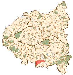
Orly is a commune in the southern suburbs of Paris, France. It is located 12.7 km (7.9 mi) from the center of Paris.
Orly Airport (Paris, France) was named after Ukrainian Grégoire_Orlyk [citation needed]
The name of Orly came from Latin Aureliacum, "the villa of Aurelius".
Paris-Orly Airport partially lies on the territory of the commune of Orly,[2] which gave its name to the airport.
Transport
Orly is served by two stations on Paris RER line C: Les Saules and Orly – Ville.
Personalities
- Kery James, rapper
See also
-
 Paris portal
 - Communes of the Val-de-Marne department
References
- ↑ "Insee - Populations légales 2007 - 94054-Orly". Institut national de la statistique et des études économiques. Retrieved 2010-01-21.
- ↑ "Plan d'Orly". Mairie-Orly. Retrieved 2009-10-06.
- Mayors of Essonne Association (French)
External links
-
 Media related to Orly at Wikimedia Commons
 - Orly city council website (French)
| |||||
This article is issued from Wikipedia. The text is available under the Creative Commons Attribution/Share Alike; additional terms may apply for the media files.