Orion, Alberta
From Wikipedia, the free encyclopedia
| Orion | |
|---|---|
| Hamlet | |
 | |
 Orion | |
| Coordinates: 49°27′12″N 110°48′38″W / 49.45333°N 110.81056°WCoordinates: 49°27′12″N 110°48′38″W / 49.45333°N 110.81056°W | |
| Country |
|
| Province | Alberta |
| Region | Southern Alberta |
| Census division | 2 |
| Municipal district | County of Forty Mile No. 8 |
| Government | |
| • Governing body | County of Forty Mile No. 8 Council |
| Elevation | 895 m (2,936 ft) |
| Time zone | MST (UTC−7) |
| • Summer (DST) | MDT (UTC−6) |
| Postal code span | T0K 1S0 |
| Area code(s) | +1-403 |
| Highways | Highway 61 |
| Waterways | Pakowki lake |
Orion is a hamlet in Alberta, Canada within the County of Forty Mile No. 8.[1] The hamlet is located approximately 78 kilometres (48 mi) south of Medicine Hat along Highway 61.
Services
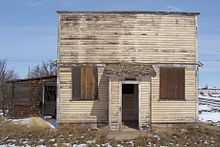
 Vacant store Orion |
The hamlet has a grocery store, a post office, a gas station/hardware store, a newly built church and many remaining facades of past businesses.
See also
References
- ↑ Alberta Municipal Affairs (2010-04-01). "Specialized and Rural Municipalities and Their Communities". Retrieved 2010-06-24.
 |
Medicine Hat |  | ||
| Etzikom | |
Manyberries | ||
| ||||
| | ||||
| Montana |
This article is issued from Wikipedia. The text is available under the Creative Commons Attribution/Share Alike; additional terms may apply for the media files.