Oregon Route 3
| ||||
|---|---|---|---|---|
 | ||||
| Route information | ||||
| Maintained by ODOT | ||||
| Length: | 43.11 mi (69.38 km) | |||
| Existed: | 1932 – present | |||
| Major junctions | ||||
| South end: |
| |||
| North end: |
| |||
| Highway system | ||||
| ||||

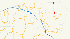
Oregon Route 3 is a state highway in the U.S. state of Oregon. It is located entirely within Wallowa County. OR 3 is the lowest numbered highway in the state of Oregon, of any type (state, federal, or Interstate). It is also known as the Enterprise-Lewiston Highway No. 11 (see Oregon highways and routes).
Route description
OR 3 has its southern terminus at a junction with Oregon Route 82 in the city of Enterprise. It runs north/south, passing near the small community of Flora. It terminates at the Washington border. The route, known as the Enterprise-Lewiston Highway, continues north through Anatone and Asotin, Washington and into Clarkston, Washington as State Route 129. From Clarkston, U.S. Route 12 provides direct access to Lewiston, Idaho.
Notable landmarks
- Joseph Canyon Viewpoint, part of the Nez Perce National Historical Park
History
An earlier routing passed through the community of Paradise, located east of the highway's current location.[1]
Major intersections
- Note: mileposts do not reflect actual mileage due to realignments.
The entire route is in Wallowa County.
| Location | Mile[2] | Destinations | Notes |
|---|---|---|---|
| Enterprise | 43.19 | ||
| 9.48 | Flora, Troy | ||
| 0.00 | Washington state line | ||
References
- ↑ Starmont, Leon (January 26, 1947). "Wallowa Here We Come!". The Spokesman-Review. Retrieved 2009-12-17.
- ↑ Oregon Department of Transportation, Public Road Inventory (primarily the Digital Video Log), accessed April 2008
