Orava (river)
From Wikipedia, the free encyclopedia
| Orava | |
| Hungarian: Árva, German: Arwa, Polish: Orawa | |
| River | |
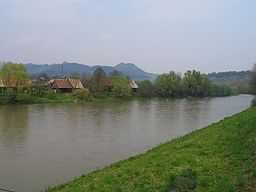
 Orava River at Dolný Kubín, showing houses of Záskalie neighbourhood | |
| Country | Slovakia |
|---|---|
| Source | Orava reservoir, taking water from White Orava in Slovakia and from Black Orava in Poland |
| - elevation | 601 m (1,972 ft) |
| - coordinates | 49°23′N 19°33′E / 49.383°N 19.550°E |
| Mouth | Váh river |
| - location | Kraľovany |
| - elevation | 430.7 m (1,413 ft) |
| - coordinates | 49°09′N 19°09′E / 49.150°N 19.150°E |
| Length | 60.9 km (38 mi) |
| Basin | 1,991.8 km2 (769 sq mi) |
| Discharge | mouth |
| - average | 34.5 m3/s (1,218 cu ft/s) |
| - max | 1,120 m3/s (39,552 cu ft/s) |
| - min | 2.3 m3/s (81 cu ft/s) |
The Orava (Hungarian: Árva) is a 60.9 km long river in north-western Slovakia passing through a picturesque country, in the Orava county. Its source is nowadays the Orava water reservoir whose waters flooded the confluence of Biela (White) Orava and Čierna (Black) Orava in 1953. It flows into the river Váh near the village of Kraľovany.
External links
| Wikimedia Commons has media related to Orava River. |
This article is issued from Wikipedia. The text is available under the Creative Commons Attribution/Share Alike; additional terms may apply for the media files.