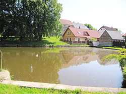
Onomyšl
From Wikipedia, the free encyclopedia
| Onomyšl | |
|---|---|
| Municipality and village | |
 | |
| Country |
|
| Region | Central Bohemian Region |
| District | Kutná Hora District |
| Area | |
| • Total | 4.97 sq mi (12.88 km2) |
| Elevation | 1,450 ft (442 m) |
| Population (1.1.2013) | |
| • Total | 294 |
| • Density | 59/sq mi (23/km2) |
| Time zone | CET (UTC+1) |
| • Summer (DST) | CEST (UTC+2) |
| Postal code | 285 03 or 285 04 |
Onomyšl is a village and municipality in Kutná Hora District in the Central Bohemian Region of the Czech Republic. The municipality covers an area of 13km² and as of 2006 it had a population of 283. The municipality of Onomyšl also includes: villages Křečovice Miletín and Rozkoš and forester's house in the Budy.
References
- This article was initially translated from the Czech Wikipedia.
Coordinates: 49°54′N 15°07′E / 49.900°N 15.117°E
| Wikimedia Commons has media related to Onomyšl. |
This article is issued from Wikipedia. The text is available under the Creative Commons Attribution/Share Alike; additional terms may apply for the media files.