Omiroupoli
From Wikipedia, the free encyclopedia
| Omiroupoli Ομηρούπολη | |
|---|---|
| Location | |
 Omiroupoli | |
| Coordinates | 38°24′N 26°7′E / 38.400°N 26.117°ECoordinates: 38°24′N 26°7′E / 38.400°N 26.117°E |
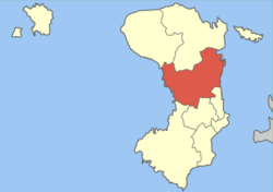
Location within the regional unit  | |
| Government | |
| Country: | Greece |
| Administrative region: | North Aegean |
| Regional unit: | Chios |
| Municipality: | Chios |
| Population statistics (as of 2001)[1] | |
| Municipal unit | |
| - Population: | 7,335 |
| - Area: | 155.015 km2 (60 sq mi) |
| - Density: | 47 /km2 (123 /sq mi) |
| Other | |
| Time zone: | EET/EEST (UTC+2/3) |
| Elevation: | 0 m (0 ft) |
| Postal code: | 822 00 |
| Telephone: | 22710 |
| Auto: | ΧΙ |
| Website | |
| www.homeroupolis.gr | |
Omiroupoli (Greek: Ομηρούπολη) is a former municipality in the central part of on the island of Chios, North Aegean, Greece. Since the 2011 local government reform it is part of the municipality Chios, of which it is a municipal unit.[2] Population 7,335 people (2001 census). The seat of the municipality was Vrontados (pop. 4,554), the second largest town on the island (after Chios (town)). The next largest towns are Lagkáda (916), Karyaí (763), and Sykiáda (571).
Tradition claims that epic poet Homer (Όμηρος) was born and lived here, thus the name of the municipal unit.
Historical population
| Year | Population |
|---|---|
| 1991 | 7,477 |
| 2001 | 7,335 |
See also
References
- ↑ De Facto Population of Greece Population and Housing Census of March 18th, 2001 (PDF 793 KB). National Statistical Service of Greece. 2003.
- ↑ Kallikratis law Greece Ministry of Interior (Greek)
External links
- Official website (Greek)
| ||||||||||||||||||||||||||
This article is issued from Wikipedia. The text is available under the Creative Commons Attribution/Share Alike; additional terms may apply for the media files.