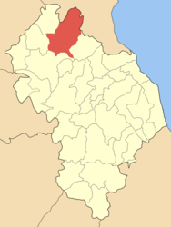
Olympos, Larissa
| Olympos Όλυμπος | |
|---|---|
| Location | |
 Olympos | |
| Coordinates | 39°59′N 22°12′E / 39.983°N 22.200°ECoordinates: 39°59′N 22°12′E / 39.983°N 22.200°E |
Location within the regional unit  | |
| Government | |
| Country: | Greece |
| Administrative region: | Thessaly |
| Regional unit: | Larissa |
| Municipality: | Elassona |
| Population statistics (as of 2001)[1] | |
| Municipal unit | |
| - Population: | 3,588 |
| - Area: | 303.96 km2 (117 sq mi) |
| - Density: | 12 /km2 (31 /sq mi) |
| Other | |
| Time zone: | EET/EEST (UTC+2/3) |
| Elevation (min-max): | 400–2,911 m (1312–9551 ft) |
| Postal code: | 402 00 |
| Auto: | ΡΙ |
Olympos (Greek: Όλυμπος) is a former municipality in the Larissa regional unit, Thessaly, Greece. Since the 2011 local government reform it is part of the municipality Elassona, of which it is a municipal unit.[2] Population 3,588 (2001). The seat of the municipality was in Kallithea. The municipality was named after the nation's tallest summit, Mount Olympus.
Subdivisions
The municipal unit Olympos is subdivided into the following communities (constituent villages in brackets):
- Flampouro (Skopia, Sparmos, Vrysopoules)
- Kallithea Elassonos (Kallithea, Petroto)
- Kokkinogeio
- Kokkinopilos (Kokkinopilos, Kalyvia)
- Lofos (Lofos, Asprochoma)
- Olympiada
- Pythio
Population
| Year | Population |
|---|---|
| 1991 | 4,410 |
| 2001 | 3,588 |
Geography
The municipality is mountainous, especially in the northeastern part, where Greece's tallest point, Mount Olympus, is situated. The village Kallithea is situated in the lower southwestern part, which is characterised by small rivers and farmlands. The Greek National Road 13 (Elassona - Katerini) passes through the municipal unit. Elassona lies south of Olympos, and the Pieria regional unit lies to the northeast.
External links
References
- ↑ De Facto Population of Greece Population and Housing Census of March 18th, 2001 (PDF 793 KB). National Statistical Service of Greece. 2003.
- ↑ Kallikratis law Greece Ministry of Interior (Greek)
| |||||||||||||||||||||||||||||