Olifants River (Limpopo)
| Olifants River (Lepelle or Obalule) | |
| Olifantsrivier, Rio dos Elefantes | |
| River | |
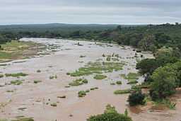
 Olifants River as it flows through the Kruger National Park | |
| Name origin: Olifant means "elefant" in Afrikaans, Obalule, means "long, stretched-out one" and Lepelle means "slow-flowing" or "distant"[1] | |
| Country | South Africa and Mozambique |
|---|---|
| Provinces | Mpumalanga, Limpopo and Gaza |
| Tributaries | |
| - left | Letaba River |
| - right | Steelpoort River |
| Source | Near Bethal |
| - location | Mpumalanga, South Africa |
| - elevation | 1,800 m (5,906 ft) |
| - coordinates | [//tools.wmflabs.org/geohack/geohack.php?pagename=Olifants_River_%28Limpopo%29¶ms=26_20_33_S_29_49_47_E_type:river_region: 26°20′33″S 29°49′47″E / 26.34250°S 29.82972°E] |
| Mouth | Limpopo River |
| - location | Gaza Province, Mozambique |
| - coordinates | [//tools.wmflabs.org/geohack/geohack.php?pagename=Olifants_River_%28Limpopo%29¶ms=24_6_44_S_32_38_25_E_type:river_region: 24°6′44″S 32°38′25″E / 24.11222°S 32.64028°E] |
| Basin | 54,570 km2 (21,070 sq mi) |
 Location of the Olifants River mouth
| |
| [2] | |

The Olifants River, Lepelle[3] or Obalule[4] (Afrikaans: Olifantsrivier; Portuguese: Rio dos Elefantes) is a river in South Africa and Mozambique, a tributary of the Limpopo River. It falls into the Drainage Area B of the Drainage basins of South Africa. The historical area of the Pedi people, Sekhukhuneland, is located between the Olifants River and one of its largest tributaries, the Steelpoort River.[5]
Course
The Olifants River has its origin between Breyten and Bethal, Mpumalanga Province.[6] It flows north towards Limpopo Province through Witbank Dam and then the Loskop Dam and is forced east by the Transvaal Drakensberg, cutting through at the Abel Erasmus Pass and then flowing east further across Limpopo Province to join with the Letaba River. It crosses into Gaza Province, Mozambique, after cutting through the Lebombo Mountains by way of the Olifants Gorge, becoming the Rio dos Elefantes, and finally joining the Limpopo River after 40 km before it enters the Indian Ocean at Xai-Xai north of Maputo.[7]
Overgrazing in sections of its middle course result in the river carrying away eroded soil after heavy rains.[8] The Olifants river has become one of the most heavily polluted rivers in South Africa, not by human or industrial waste, but by thriving green algae.[9]
Tributaries
The Olifants River's largest tributaries are the Letaba River[10] and the Steelpoort River.[11] Other tributaries are the Tongwane, the Blyde River, Moses River, Spekboom River, Timbavati River, Nkumpi River, Ga-Selati River, Klaserie River, Makhutswi River and Mohlapitse Rivers. Some tributaries, notably the Klein Olifants River (origin near Hendrina, joins the Olifants River downstream of the Middelburg Dam), Elands River, Wilge River and Bronkhorstspruit River, rise in the Highveld grasslands.[12] The Shingwedzi River flows close to the northeastern side of the Massingir Dam reservoir and joins the left bank of the Olifants about 12 km downstream from the dam wall.[13]
Dams
Thirty large dams in the Olifants River Catchment include the following:
South Africa
- Witbank Dam
- Rhenosterkop Dam, in the Elands River
- Rust de Winter Dam
- Blyderivierspoort Dam
- Loskop Dam
- Middelburg Dam on the Klein Olifants River
- Ohrigstad Dam
- Arabie Dam
- Phalaborwa Barrage
Mozambique
See also
- List of rivers in South Africa
- Water Management Areas
References
- ↑ Transvaal Indigenous Place Names
- ↑ "State of Rivers Report - The Olifants River System". Council for Scientific and Industrial Research. Retrieved 2009-02-19.
- ↑ Olifants River now called Lepelle
- ↑ Transvaal Indigenous Place Names
- ↑ The Ba Pedi
- ↑ Major rivers and streams within the Limpopo River Basin
- ↑ Key rivers of South Africa
- ↑ The Olifants River System
- ↑ Contaminated Olifants River Running Out of Time
- ↑ Luvuvu Lethaba WMA 2
- ↑ Major rivers and streams within the Limpopo River Basin
- ↑ Olifants river WMA 4
- ↑ Shingwedzi River why is it the most polluted river in the KNP?
- ↑ Massingir Dam & Flooding of Olifants Gorge
External links
| Wikimedia Commons has media related to Olifants River (Mpumalanga). |
- The Olifants River Basin, South Africa
- Massingir Dam Rehabilitation
- South African Geographical Names