Ocmulgee River
| Ocmulgee River | |
| River | |
 The Ocmulgee River at Macon | |
| Country | United States |
|---|---|
| State | Georgia |
| Tributaries | |
| - left | South River |
| - right | Yellow River |
| Source | Confluence of South, Yellow, and Alcovy rivers |
| - location | Lloyd Shoals Dam, Georgia |
| - coordinates | 33°19′15″N 83°50′39″W / 33.32083°N 83.84417°W |
| Mouth | |
| - location | Hazelhurst, Georgia |
| Length | 255 mi (410 km) |
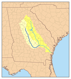 Map of the Ocmulgee River watershed highlighted
| |
The Ocmulgee River (ok-MUHL-gee) is a tributary of the Altamaha River, approximately 255 mi (410 km) long, in the U.S. state of Georgia. Noted for its relatively unspoiled and gentle current, it provides the principal drainage for a large section of the Piedmont and coastal plain of central Georgia.
Description
It is formed in north central Georgia southeast of Atlanta by the confluence of the Yellow, South, and Alcovy rivers, which join as arms of the Lake Jackson reservoir. It flows southeast past Macon, founded on the fall line, and joins the Oconee from the northwest to form the Altamaha near Lumber City.
Downstream from Lake Jackson, the river flows freely and is considered relatively unspoiled among the rivers of the region. Its low gradient of approximately 1 ft/mile (24 cm/km) gives it a wide and peaceful current along most of its course; it is a popular destination for canoeing. It receives treated wastewater from 13 facilities along its course. The river is a popular destination for catfishing and bass fishing.
On June 2, 1932 George W Perry caught the world-record Largemouth Bass in Montgomery Lake in Telfair County, Georgia. The fish weighed 22¼ pounds. While the record has not been broken, it was tied in 2010. Montgomery Lake, now shallow and silted in, was an oxbow lake on the Ocmulgee River.
History
The banks of the river were inhabited by people of the Mississippian culture between the 10th and 12th centuries. The river passes the remnants of several prehistoric Native American villages at Ocmulgee National Monument in Macon. For this reason the Ocmulgee site is also referred to as the "Macon Plateau". It was established around 950 CE by a population that most likely migrated from the Tennessee River Valley, based on pottery evidence. The inhabitants established a chiefdom, which was common for the Mississippian area. The site has eight, distantly spaced, large platform mounds and an earth lodge. Within the lodge, forty-seven seats were formed in a bench around the perimeter of the room. Across from this was a three-seated bench in the shape of an eagle effigy; it likely was used by the chiefdom leaders. About 1150 CE, the people abandoned the site.
In 1540 the Spanish explorer Hernando de Soto traversed the region and baptized Native American converts in the river. His expedition had conflicts with some of the natives, drew from their resources, and exposed many to new infectious diseases. These produced epidemics and high fatalities, as the Native Americans had no immunity to the diseases. [citation needed]
In the 18th century, the Hitchiti, later part of the Creek Indian confederation, lived near present-day Macon in Ocmulgee Fields. The name of the river probably comes from a Hitchiti words oki, "water", plus molki, "bubbling" or "boiling".[1]
In 1806, the U.S. acquired the area between the Oconee and Ocmulgee rivers from the Creek Indians by the First Treaty of Washington. That same year United States Army established Fort Benjamin Hawkins overlooking the Ocmulgee Fields. In 1819 the Creek Indians held their last meeting at Ocmulgee Fields.
In the same year, the McCall brother established a barge-building operation at Macon. The first steamboat arrived on the river in 1829. During the 19th century, the river provided the principal water navigation route for Macon, allowing the development of the cotton industry in the surrounding region. In 1842 the river was connected by railroad to Savannah. The river froze from bank to bank in 1886. In 1994 devastating floods on the river after heavy rains caused widespread damage around Macon.[2]
Ocmulgee creeks
Major creeks that flow into the Ocmulgee River include:
- Tucsawhatchee Creek
- Echeconnee Creek
- This tributary's name means "deer trap" in the Muscogee language, the language of the Creek indians. It refers to the steep incline of the creek where Creeks would trap deer, luring them into steep areas and then charging them.
- Alligator Creek
- Big Indian Creek
- Coley Creek
- Big Horse Creek
- Flat Creek
- Folsom Creek
- Horse Creek
- Jordan Creek
- Limestone Creek
- Little Ocmulgee River (Gum Swamp Creek)
- Little Shellstone Creek
- Little Sturgeon Creek
- Mossy Creek
- Otter Creek
- Richland Creek
- Sandy Run Creek
- Savage Creek
- Shellstone Creek
- South Shellstone Creek
- Sturgeon Creek
- Sugar Creek
- Ten Mile Creek
See also
References
- ↑ Bright, William (2004). Native American placenames of the United States. University of Oklahoma Press. p. 347. ISBN 978-0-8061-3598-4. Retrieved 16 September 2011.
- ↑ "1994 flood", Centers for Disease Control
- Snow, Dean (2010). Archaeology of Native North America. Upper Saddle River, NJ: Prentice Hall. pp. 208–209. ISBN 978-0-13-615686-4.