Oberweißbach
From Wikipedia, the free encyclopedia
| Oberweißbach | ||
|---|---|---|
 | ||
| ||
 Oberweißbach | ||
Location of Oberweißbach within Saalfeld-Rudolstadt district  | ||
| Coordinates: 50°34′58″N 11°8′40″E / 50.58278°N 11.14444°ECoordinates: 50°34′58″N 11°8′40″E / 50.58278°N 11.14444°E | ||
| Country | Germany | |
| State | Thuringia | |
| District | Saalfeld-Rudolstadt | |
| Municipal assoc. | Bergbahnregion/Schwarzatal | |
| Government | ||
| • Mayor | Jens Ungelenk | |
| Area | ||
| • Total | 9.62 km2 (3.71 sq mi) | |
| Elevation | 670 m (2,200 ft) | |
| Population (2012-12-31)[1] | ||
| • Total | 1,803 | |
| • Density | 190/km2 (490/sq mi) | |
| Time zone | CET/CEST (UTC+1/+2) | |
| Postal codes | 98744 | |
| Dialling codes | 036705 | |
| Vehicle registration | SLF | |
| Website | Official website | |
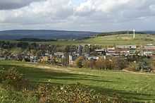
Oberweißbach (or Oberweissbach) is a town in the district of Saalfeld-Rudolstadt, in Thuringia, Germany.

Panoramic view
Overview

Froebeltower on the Kirchberg (785 m NN), Oberweißbach
It is situated in the Thuringian Forest, 17 km (11 mi) southwest of Saalfeld. On 1 December 2008, it incorporated the former municipality Lichtenhain/Bergbahn.
References
- ↑ "Bevölkerung der Gemeinden, erfüllenden Gemeinden und Verwaltungsgemeinschaften nach Geschlecht in Thüringen". Thüringer Landesamt für Statistik (in German). 13 July 2013.
External links
![]() Media related to Oberweißbach at Wikimedia Commons
Media related to Oberweißbach at Wikimedia Commons
This article is issued from Wikipedia. The text is available under the Creative Commons Attribution/Share Alike; additional terms may apply for the media files.
