Obertraubling
| Obertraubling | ||
|---|---|---|
| ||
 Obertraubling | ||
Location of Obertraubling within Regensburg district 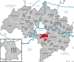 | ||
| Coordinates: 48°57′57″N 12°10′01″E / 48.96583°N 12.16694°ECoordinates: 48°57′57″N 12°10′01″E / 48.96583°N 12.16694°E | ||
| Country | Germany | |
| State | Bavaria | |
| Admin. region | Oberpfalz | |
| District | Regensburg | |
| Subdivisions | 5 Ortsteile | |
| Government | ||
| • Mayor | Alfons Lang (CSU) | |
| Area | ||
| • Total | 24.82 km2 (9.58 sq mi) | |
| Elevation | 344 m (1,129 ft) | |
| Population (2012-12-31)[1] | ||
| • Total | 7,766 | |
| • Density | 310/km2 (810/sq mi) | |
| Time zone | CET/CEST (UTC+1/+2) | |
| Postal codes | 93083 | |
| Dialling codes | 09401 | |
| Vehicle registration | R | |
| Website | www.obertraubling.de | |

Obertraubling is a municipality in Bavaria, Upper Palatinate (German: Oberpfalz), in the district of Regensburg.
Geographical Location
Obertraubling ist located directly on the southend of the City of Regensburg, the capital of Upper Palatinate.
Community Population divided by subdivisions:
- Einthal (28)
- Embach (44)
- Gebelkofen (568)
- Höhenhof (23)
- Niedertraubling (653)
- Oberhinkofen (920)
- Obertraubling (4,121)
- Piesenkofen (686)
- Scharmassing (197)
- Tenacker (11)
In 1972 the so far independent municipalities Niedertraubling, Gebelkofen and Oberhinkofen joined with Obertraubling and became one municipality.
History
Locally excavated stone axes and vessels dating back to 5000 BC suggest that Obertraubling has been inhabited since the Stone Age. Bronze Age burial mounds in the Neutraubling section dating back to 1,800 BC also indicate human habitation in this part of the Danube flood plain. A Roman farm was established here in the third century AD.
Obertraubling is first mentioned in a 817 AD document concerning a land swap. The name originates from the 11th century landowners, the 'Traublinger' noble family.
During the Second World War Obertraubling was used as an airbase and factory for the Messerschmitt aircraft manufacturing company.
Between the end of 1940 and April 23, 1945, the factory was able to house up to 2,750 slave laborers at a time.[2]
Between 20 February, 1945 and 26 April, 1945, inmates of Flossenbürg concentration camp were held there until forced into a 'death march' to Dachau concentration camp.[3]
Politics
Former and present Mayor:
- Sebastian Pindorfer from 1926 till 1941
- Josef Wieland from 1941 till 1945
- Max Hirtreiter from 1945 bis 1948
- Josef Bäumel (PWG) from 1948 till 1967
- Hermann Zierer (CSU) from 1967 till 1981
- Leo Graß (FW) from 1981 till 1996
- Alfons Lang (CSU) from 1996 till 2014
Community Council:
- Gertraud Grief (CSU), Franz Aukofer (CSU), Marcus Weigl(CSU), Werner Schwarz(CSU), Rainer Tetzlaff (CSU), Jürgen Hofer (CSU), Petra Rothammer (CSU), Sebastian Treitinger (CSU), Gottfried Gruber (CSU), Anton Schaffer (CSU), Josef Heigl (CSU), Beate Konrad (SPD), Rainer Sinn (SPD), Franz Rieger (SPD) Anton Stadler (UBO), Wolfgang Hankofer (UBO), Karl Span (FW), Rudolf Graß (FW), Anna-Elise Dechant (FW), Michael Hitzler (FW).
Terms of election: every six years (May 2008 till Mai 2014).
Education
- Hermann-Zierer-Schule, Piesenkofener Str. 11, public school (1st through 4th grade)
- Realschule, Walhallastraße 24, secondary school (5th through 10th grade)
- Public library, Brunnweg
Twin towns
References
- ↑ "Fortschreibung des Bevölkerungsstandes". Bayerisches Landesamt für Statistik und Datenverarbeitung (in German). 31 December 2012.
- ↑ (German) Helmut Halter: Stadt unterm Hakenkreuz, Universitätsverlag Regensburg 1994, S. 377
- ↑ (German) Heike Wolter et al.: Sterben und Überleben im KZ-Außenlager Obertraubling, edition riedenburg 2011