Oberteuringen
From Wikipedia, the free encyclopedia
| Oberteuringen | ||
|---|---|---|
| ||
 Oberteuringen | ||
Location of Oberteuringen within Bodenseekreis district 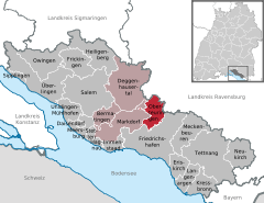
 | ||
| Coordinates: 47°43′30″N 09°28′15″E / 47.72500°N 9.47083°ECoordinates: 47°43′30″N 09°28′15″E / 47.72500°N 9.47083°E | ||
| Country | Germany | |
| State | Baden-Württemberg | |
| Admin. region | Tübingen | |
| District | Bodenseekreis | |
| Government | ||
| • Mayor | Karl-Heinz Beck (CDU) | |
| Area | ||
| • Total | 20.06 km2 (7.75 sq mi) | |
| Elevation | 451 m (1,480 ft) | |
| Population (2012-12-31)[1] | ||
| • Total | 4,452 | |
| • Density | 220/km2 (570/sq mi) | |
| Time zone | CET/CEST (UTC+1/+2) | |
| Postal codes | 88094 | |
| Dialling codes | 07546 | |
| Vehicle registration | FN | |
| Website | www.oberteuringen.de | |

Oberteuringen is a town in the district of Bodensee in Baden-Württemberg in Germany.
It is located approximately 8 kilometers north of the Bodensee and south-east of the Gehrenberg mountain.
The nearest cities are Markdorf, Friedrichshafen, Tettnang and Ravensburg.
Oberteuringen council district comprises the villages Rammetshofen, Bitzenhofen, Hefigkofen, Neuhaus, Unterteuringen, Bibruck, Vittenhaag und Remette.
References
- ↑ [Statistisches Bundesamt – Gemeinden in Deutschland mit Bevölkerung am 31.12.2012 (XLS-Datei; 4,0 MB) (Einwohnerzahlen auf Grundlage des Zensus 2011) "Gemeinden in Deutschland mit Bevölkerung am 31.12.2012"]. Statistisches Bundesamt (in German). 12 November 2013.
| |||||||
This article is issued from Wikipedia. The text is available under the Creative Commons Attribution/Share Alike; additional terms may apply for the media files.