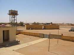
Nukhayb
From Wikipedia, the free encyclopedia
Coordinates: 32°2′28″N 42°15′17″E / 32.04111°N 42.25472°E
| An Nukhayb النخيب | |
|---|---|
 | |
 An Nukhayb | |
| Coordinates: 32°2′28″N 42°15′17″E / 32.04111°N 42.25472°E | |
| Country |
|
| Province | Al-Anbar |
An Nukhayb (Arabic: النخيب, alt. Nukhaib) is a city in Al-Anbar province in Iraq.
Nukhayb is located at the largest road junction in the region, with roads going south to the Saudi Arabian border, north to the Ramadi–Jordan highway, and northeast to Karbala. Nukhayb is the last Iraqi town before pilgrims cross into Saudi Arabia on their pilgrimage to Mecca.[citation needed] It has two satellite villages to the north, Habbariya (28km) and Kesrah (51km).[1]
History
During the British Mandate, John Bagot Glubb established a post at the well of Nukhayb to allow the Iraqi government to control its western deserts.[2]:342
References
- ↑ Bajallat Markaz Buḥūth Al-Tārīkh Al-Ṭabīʻī. The Center. 1975. Retrieved 15 September 2013.
- ↑ Sir John Bagot Glubb (1960). War in the desert: an R. A. F. frontier campaign. Hodder and Stoughton. Retrieved 15 September 2013.
Further reading
- Sarhan, Abbas. karbala and anbar dispute forgotten town. niqash. 03 Jun. 2009
- Visser, Reidar. Disputed Territories in Iraq: The Practical Argument Against Self-Determination in Kirkuk. historiae.org. 25 May 2009
- Geology of the Arabian Peninsula, Southwestern Iraq. K. M. Al Naqib. Geological Survey Professional Paper, Geological Survey (U.S.) 1949
- D. C. P. Thalen (1979). Ecology and utilization of desert shrub rangelands in Iraq. W. Junk. Retrieved 15 September 2013.
This article is issued from Wikipedia. The text is available under the Creative Commons Attribution/Share Alike; additional terms may apply for the media files.